
Griselles (Loiret)
| Griselles | ||
|---|---|---|
|
||
| region | Center-Val de Loire | |
| Department | Loiret | |
| Arrondissement | Montargis | |
| Canton | Courtenay | |
| Community association | Quatre Vallées | |
| Coordinates | 48 ° 5 ′ N , 2 ° 50 ′ E | |
| height | 87-107 m | |
| surface | 30.32 km 2 | |
| Residents | 792 (January 1, 2017) | |
| Population density | 26 inhabitants / km 2 | |
| Post Code | 45210 | |
| INSEE code | 45161 | |
| Website | http://www.griselles.fr/ | |
 Town hall (Mairie) of Griselles |
||

Griselles is a French municipality with 792 inhabitants (as of January 1 2017) in the department of Loiret in the region Center-Val de Loire . Griselles belongs to the arrondissement of Montargis and the canton of Courtenay (until 2015: canton Ferrières-en-Gâtinais ). The inhabitants are called Grisellois .
geography
Griselles is located about 55 kilometers east-northeast of Orléans in the Gâtinais am Cléry region . Griselles is surrounded by the neighboring municipalities of Chevannes in the north, Pers-en-Gâtinais in the northeast, La Selle-sur-le-Bied in the east and southeast, Paucourt in the south and southwest, Juranville in the west and southwest and Ferrières-en-Gâtinais in the west .
The A19 car route runs through the south of the municipality .
Population development
| year | 1962 | 1968 | 1975 | 1982 | 1990 | 1999 | 2006 | 2013 |
| Residents | 464 | 420 | 392 | 481 | 532 | 620 | 747 | 800 |
| Source: Cassini and INSEE | ||||||||
Attractions
- Saint-Aignan church, restored in 1873
- Bois-le-Roi Castle, built on the old castle
- La Fontaine Castle
- Weir bridge over the Cléry ( Le Gril de Corbelin ) from the 15th century, Monument historique since 1929
- Mill Tousset, Monument historique since 1991
- Mill Les Aulnes
- Montargis forest

Saint-Aignan church
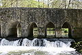
Le Gril de Corbelin bridge

.JPG)