
Autry-le-Châtel
| Autry-le-Châtel | ||
|---|---|---|
.svg)
|
|
|
| region | Center-Val de Loire | |
| Department | Loiret | |
| Arrondissement | Montargis | |
| Canton | Gien | |
| Community association | Berry Loire Puisaye | |
| Coordinates | 47 ° 36 ' N , 2 ° 36' E | |
| height | 141-236 m | |
| surface | 50.56 km 2 | |
| Residents | 961 (January 1, 2017) | |
| Population density | 19 inhabitants / km 2 | |
| Post Code | 45500 | |
| INSEE code | 45016 | |
 Town hall (Mairie) of Autry-le-Châtel |
||

Autry-le-Chatel is a French commune with a population of 961 (as at 1st January 2017) in the department of Loiret in the region Center-Val de Loire . It belongs to the arrondissement of Montargis and is part of the canton of Gien (until 2015: canton of Châtillon-sur-Loire ). The inhabitants are called Castelautryens .
geography
Autry-le-Châtel is about 65 kilometers southeast of Orléans . Neighboring municipalities of Autry-le-Châtel are Poilly-lez-Gien in the north, Saint-Martin-sur-Ocre in the north-east, Saint-Brisson-sur-Loire in the east and north-east, Saint-Firmin-sur-Loire in the east, Cernoy- en-Berry in the south and southeast, Blancafort in the south and southwest and Coullons in the west.
Population development
| year | 1962 | 1968 | 1975 | 1982 | 1990 | 1999 | 2006 | 2013 |
| Residents | 879 | 853 | 835 | 937 | 919 | 1,015 | 1,050 | 1.004 |
| Source: Cassini and INSEE | ||||||||
Attractions
- Saint-Etienne church from the 19th century
- Small castle ( petite château ) from the 15th century, monument historique since 1971
- Remains of the old castle from the 12th century
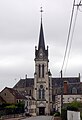
Saint-Etienne church

historical photo of the small castle

