Montcresson
| Montcresson | ||
|---|---|---|

|
|
|
| region | Center-Val de Loire | |
| Department | Loiret | |
| Arrondissement | Montargis | |
| Canton | Lorris | |
| Community association | Canaux et Forêts en Gâtinais | |
| Coordinates | 47 ° 54 ' N , 2 ° 48' E | |
| height | 112-150 m | |
| surface | 21 km 2 | |
| Residents | 1,281 (January 1, 2017) | |
| Population density | 61 inhabitants / km 2 | |
| Post Code | 45700 | |
| INSEE code | 45212 | |
| Website | http://montcresson.com/ | |
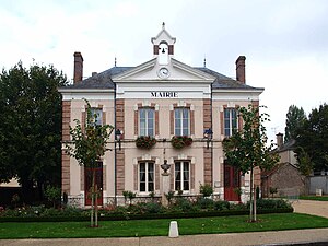
 Montcresson City Hall |
||
Montcresson is a commune with 1,281 inhabitants (as of January 1 2017) in the Loiret in the region Center-Val de Loire . The municipality belongs to the arrondissement of Montargis and the canton of Lorris (until 2015: canton of Châtillon-Coligny ). The inhabitants are called Montcressonais .
geography
Montcresson is located about 67 kilometers east of Orléans in central France in the Gâtinais countryside on the eastern edge of the Loiret department on the Loing River and the Briare Canal . Montcresson is surrounded by the neighboring communities of Conflans-sur-Loing in the north, Gy-les-Nonains in the east and northeast, Montbouy in the south, Pressigny-les-Pins in the southwest and Cortrat in the west.
Population development
| 1962 | 1968 | 1975 | 1982 | 1990 | 1999 | 2006 | 2013 |
|---|---|---|---|---|---|---|---|
| 654 | 610 | 652 | 883 | 1,161 | 1,266 | 1,303 | 1,300 |
| Source: Cassini and INSEE | |||||||
Attractions
- Saint-Léger church from the 12th century, current building from 1661
- La Forêt castle from the 17th century
- Wallburg
Web links
Commons : Montcresson - collection of images, videos and audio files


