
Fontenay-sur-Loing
| Fontenay-sur-Loing | ||
|---|---|---|
|
||
| region | Center-Val de Loire | |
| Department | Loiret | |
| Arrondissement | Montargis | |
| Canton | Courtenay | |
| Community association | Quatre Vallées | |
| Coordinates | 48 ° 6 ′ N , 2 ° 36 ′ E | |
| height | 70-109 m | |
| surface | 9.73 km 2 | |
| Residents | 1,720 (January 1, 2017) | |
| Population density | 177 inhabitants / km 2 | |
| Post Code | 45210 | |
| INSEE code | 45148 | |
| Website | http://www.mairie-fontenaysurloing.fr/ | |
 Town hall (Mairie) of Fontenay-sur-Loing |
||

Fontenay-sur-Loing is a French commune with 1,720 inhabitants (as of January 1 2017) in the department of Loiret in the region Center-Val de Loire . Fontenay-sur-Loing belongs to the arrondissement of Montargis and the canton of Courtenay (until 2015: canton Ferrières-en-Gâtinais ). The inhabitants are called Fontenaysia .
geography
Fontenay-sur-Loing is located about 95 kilometers south of Paris in the Gâtinais countryside on the Cléry River , which flows into the Loing on the northwestern edge of the municipality , which forms the western municipal boundary. Fontenay-sur-Loing is surrounded by the neighboring communities of Dordives in the north, Ferrières-en-Gâtinais in the east, Paucourt in the south-east, Cepoy in the south, Girolles in the south-west and Nargis in the west and north-west.
The Autoroute A19 and the former Route nationale 7 (today's D2007) cross in the municipality .
Population development
| year | 1962 | 1968 | 1975 | 1982 | 1990 | 1999 | 2006 | 2012 |
| Residents | 674 | 715 | 919 | 960 | 1,163 | 1,425 | 1,676 | 1,744 |
| Source: Cassini and INSEE | ||||||||
Attractions
- Saint-Victorien church from 1860
- Notre-Dame de la Route chapel
- Archaeological excavation area, Monument historique since 1977
- House built at the end of the 15th century, monument historique since 1931
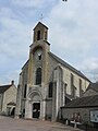
Saint-Victorin Church

Notre-Dame de la Route chapel

