Bonny-sur-Loire
| Bonny-sur-Loire | ||
|---|---|---|

|
|
|
| region | Center-Val de Loire | |
| Department | Loiret | |
| Arrondissement | Montargis | |
| Canton | Gien | |
| Community association | Berry Loire Puisaye | |
| Coordinates | 47 ° 34 ′ N , 2 ° 50 ′ E | |
| height | 130-189 m | |
| surface | 25.8 km 2 | |
| Residents | 1,952 (January 1, 2017) | |
| Population density | 76 inhabitants / km 2 | |
| Post Code | 45420 | |
| INSEE code | 45040 | |
| Website | http://www.bonny-sur-loire.fr/ | |
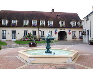
 Town hall of Bonny-sur-Loire |
||
Bonny-sur-Loire is a French commune with 1,952 inhabitants (as of January 1 2017) in the department of Loiret in the region Center-Val de Loire . It belongs to the canton of Gien (until 2015: canton of Briare ) in the arrondissement of Montargis . The inhabitants are called Bonnychons .
geography
Bonny-sur-Loire is located on the eastern bank of the Loire in the middle of the wine-growing region of the Coteaux du Giennois . Bonny-sur-Loire is surrounded by the neighboring communities of Ousson-sur-Loire in the north and north-west, Dammarie-en-Puisaye in the north and north-east, Batilly-en-Puisaye in the north-east, Thou in the east, Neuvy-sur-Loire in the south and South-east, Beaulieu-sur-Loire to the south and west and Châtillon-sur-Loire to the north-west.
The A77 autoroute and the earlier Routes nationales 7 (today's D2007), 65 (today's D965) and 726 (today's D926) run through the municipality .
Population development
| year | 1962 | 1968 | 1975 | 1982 | 1990 | 1999 | 2006 | 2017 |
| Residents | 1605 | 1701 | 1778 | 1830 | 1921 | 1924 | 2032 | 1952 |
Attractions
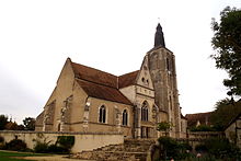
- Saint-Aignan church from the 12th century, remodeled in the 15th and 16th centuries, monument historique since 1984
- Suspension bridge over the Loire , built between 1899 and 1902

