Dammarie-sur-Loing
| Dammarie-sur-Loing | ||
|---|---|---|
|
|
||
| region | Center-Val de Loire | |
| Department | Loiret | |
| Arrondissement | Montargis | |
| Canton | Lorris | |
| Community association | Canaux et Forêts en Gâtinais | |
| Coordinates | 47 ° 47 ' N , 2 ° 54' E | |
| height | 126-177 m | |
| surface | 20.94 km 2 | |
| Residents | 489 (January 1, 2017) | |
| Population density | 23 inhabitants / km 2 | |
| Post Code | 45230 | |
| INSEE code | 45121 | |
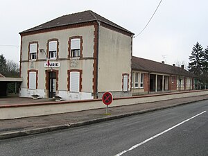
 Town hall (Mairie) of Dammarie-sur-Loing |
||
Dammarie-sur-Loing is a French municipality with 489 inhabitants (as of January 1 2017) in the department of Loiret in the region Center-Val de Loire . The municipality belongs to the arrondissement of Montargis and the canton of Lorris (until 2015: canton of Châtillon-Coligny ).
geography
Dammarie-sur-Loing is located about 74 kilometers east-southeast of Orléans in central France in the Gâtinais landscape on the eastern edge of the Loiret department on the Loing River and the Canal de Briare . There are three active locks on the canal in the municipality. Its old technology and the brands of ropes from the days of towing , which are well preserved at lock No. 21, the Écluse du Moulin Brûlé , are worth seeing .
Dammarie-sur-Loing is surrounded by the neighboring communities of Châtillon-Coligny in the north, Aillant-sur-Milleron in the east, Rogny-les-Sept-Écluses in the south and south-east, Feins-en-Gâtinais in the south-west, Adon in the west and south-west as well Sainte-Geneviève-des-Bois in the north-west.
Population development
| 1962 | 1968 | 1975 | 1982 | 1990 | 1999 | 2006 | 2013 |
|---|---|---|---|---|---|---|---|
| 474 | 463 | 406 | 375 | 380 | 467 | 505 | 510 |
| Source: Cassini and INSEE | |||||||
Attractions
- Notr-Dame church from the 12th century
- Mivoisin Castle from the 18th century
- Gévrils Castle from the 19th century
- Nailly Castle from the 15th century
- The ruins of the lock staircase next to lock number 21 of the Canal de Briare


