Marigny-les-Usages
| Marigny-les-Usages | ||
|---|---|---|

|
|
|
| region | Center-Val de Loire | |
| Department | Loiret | |
| Arrondissement | Orleans | |
| Canton | Fleury-les-Aubrais | |
| Community association | Orléans metropolis | |
| Coordinates | 47 ° 57 ' N , 2 ° 1' E | |
| height | 103-138 m | |
| surface | 9.66 km 2 | |
| Residents | 1,560 (January 1, 2017) | |
| Population density | 161 inhabitants / km 2 | |
| Post Code | 45760 | |
| INSEE code | 45197 | |
 Municipal government ( Mairie ) of Marigny-les-Usages |
||
Marigny-les-Usages is a French commune with 1,560 inhabitants (as of January 1 2017) in the department of Loiret in the region Center-Val de Loire . It belongs to the Arrondissement Orléans and the canton Fleury-les-Aubrais (until 2015: Canton Chécy ).
geography
Marigny-les-Usages is about ten kilometers northeast of Orléans on the Bionne . Neighboring communities of Marigny-les-Usages are Rebréchien in the north and north-east, Loury in the north-east, Vennecy in the east, Boigny-sur-Bionne in the south, Saint-Jean-de-Braye in the south and south-west, Semoy in the south-west and Chanteau in the west.
On the eastern edge of the municipality, the former route nationale 152 (today's D2152) leads along.
Population development
| year | 1962 | 1968 | 1975 | 1982 | 1990 | 1999 | 2006 | 2013 |
| Residents | 307 | 480 | 679 | 913 | 998 | 1,172 | 1,139 | 1,229 |
| Source: Cassini and INSEE | ||||||||
Attractions
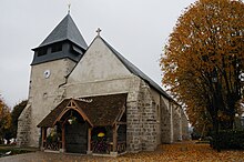
- Saint-Saturnin church, partly from the 12th century
Web links
Commons : Marigny-les-Usages - collection of images, videos and audio files

