
Épieds-en-Beauce
| Épieds-en-Beauce | ||
|---|---|---|
|
||
| region | Center-Val de Loire | |
| Department | Loiret | |
| Arrondissement | Orleans | |
| Canton | Meung-sur-Loire | |
| Community association | Terres du Val de Loire | |
| Coordinates | 47 ° 57 ' N , 1 ° 37' E | |
| height | 114-129 m | |
| surface | 40.22 km 2 | |
| Residents | 1,435 (January 1, 2017) | |
| Population density | 36 inhabitants / km 2 | |
| Post Code | 45130 | |
| INSEE code | 45134 | |
 Town hall of Épieds-en-Beauce |
||

Épieds-en-Beauce is a French commune with 1,435 inhabitants (as of January 1 2017) in the department of Loiret in the region Center-Val de Loire ; it belongs to the Arrondissement Orléans and the canton Meung-sur-Loire . The inhabitants are called Spicaciens .
geography
Épieds-en-Beauce is located about 22 kilometers west-northwest of Orléans in the Beauce . Épieds-en-Beauce is surrounded by the neighboring communities of Villamblain in the north and northwest, Tournoisis in the north and northeast, Saint-Sigismond in the east and northeast, Gérmigny in the east, Coulmiers in the southeast, Charsonville in the south and southwest and Beauce la Romaine with Prénouvellon in the West.
Population development
| year | 1962 | 1968 | 1975 | 1982 | 1990 | 1999 | 2006 | 2013 |
| Residents | 955 | 862 | 861 | 932 | 1,028 | 1,036 | 1,330 | 1,495 |
| Source: Cassini and INSEE | ||||||||
Attractions
- Saint-Privat church, built at the end of the 19th century
- Dolmen Pierres Fenats from the Neolithic period, since 1879 Monument historique
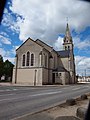
Saint-Privat Church

Dolmen


Web links
Commons : Épieds-en-Beauce - Collection of images, videos and audio files