
Ligny-le-Ribault
| Ligny-le-Ribault | ||
|---|---|---|
.svg)
|
|
|
| region | Center-Val de Loire | |
| Department | Loiret | |
| Arrondissement | Orleans | |
| Canton | La Ferté-Saint-Aubin | |
| Community association | Portes de Sologne | |
| Coordinates | 47 ° 41 ′ N , 1 ° 47 ′ E | |
| height | 84-117 m | |
| surface | 59.21 km 2 | |
| Residents | 1,236 (January 1, 2017) | |
| Population density | 21 inhabitants / km 2 | |
| Post Code | 45240 | |
| INSEE code | 45182 | |
| Website | http://www.ligny-le-ribault.info/ | |

Ligny-le-Ribault is a French commune with 1,236 inhabitants (as of January 1 2017) in the department of Loiret in the region Center-Val de Loire . It belongs to the Arrondissement Orléans and the canton La Ferté-Saint-Aubin . The inhabitants are called Lignois .
geography
Ligny-le-Ribault is about 26 kilometers south-southwest of Orléans . The Canne and the Cosson flow through the municipality . Ligny-le-Ribault is surrounded by the neighboring communities of Jouy-le-Potier in the north, La Ferté-Saint-Aubin in the east, Yvoy-le-Marron in the south and southeast, Villeny in the south, La Ferté-Saint-Cyr in the west, Saint-Laurent-Nouan to the west and north-west and Lailly-en-Val to the north-west.
Population development
| year | 1962 | 1968 | 1975 | 1982 | 1990 | 1999 | 2008 | 2017 |
| Residents | 1,032 | 939 | 895 | 960 | 1033 | 1121 | 1298 | 1236 |
| Sources: Cassini and INSEE | ||||||||
Attractions
- Saint Martin Church
- La Cour Castle
- Bon-Hôtel Castle
- Bretèche brickworks

Saint Martin Church

Bretèche brick oven
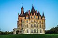
Bon-Hôtel Castle


