Semoy
| Semoy | ||
|---|---|---|

|
|
|
| region | Center-Val de Loire | |
| Department | Loiret | |
| Arrondissement | Orleans | |
| Canton | Saint-Jean-de-Braye | |
| Community association | Orléans metropolis | |
| Coordinates | 47 ° 56 ' N , 1 ° 57' E | |
| height | 108-134 m | |
| surface | 7.78 km 2 | |
| Residents | 3,176 (January 1, 2017) | |
| Population density | 408 inhabitants / km 2 | |
| Post Code | 45400 | |
| INSEE code | 45308 | |
| Website | http://www.ville-semoy.fr/ | |
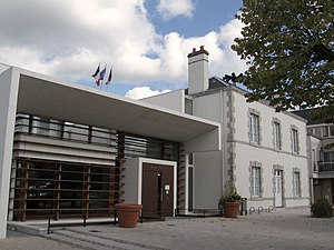
 Semoy City Hall |
||
Semoy is a commune with 3176 inhabitants (as of January 1 2017) in the Loiret in the region Center-Val de Loire . The municipality belongs to the Arrondissement Orléans and is part of the canton of Saint-Jean-de-Braye . The inhabitants are called Semeyen .
geography
Semoy is east of Orléans on the Ruet , a tributary of the Loire . The municipality is part of the Loire Valley , a UNESCO World Heritage Site since 2000. In the north is the Forêt d'Orléans. Semoy is surrounded by the municipalities of Chanteau in the north, Marigny-les-Usages in the northeast, Saint-Jean-de-Braye in the south and east, Orléans in the southwest and Fleury-les-Aubrais in the west.
history
A Benedictine priory was established in 1081, which was destroyed during the French Revolution .
Population development
| year | 1962 | 1968 | 1975 | 1982 | 1990 | 1999 | 2006 | 2017 |
| Residents | 923 | 1567 | 1792 | 1395 | 2237 | 2879 | 2928 | 3176 |
Attractions
- Notre-Dame church from the 11th century, rebuilt in the 17th century
Parish partnership
There is a partnership with the district of Brehna in the German town of Sandersdorf-Brehna in Saxony-Anhalt.

