Bou (Loiret)
| Bou | ||
|---|---|---|
|
|
||
| region | Center-Val de Loire | |
| Department | Loiret | |
| Arrondissement | Orleans | |
| Canton | Saint-Jean-de-Braye | |
| Community association | Orléans metropolis | |
| Coordinates | 47 ° 52 ' N , 2 ° 3' E | |
| height | 97-102 m | |
| surface | 6.29 km 2 | |
| Residents | 958 (January 1, 2017) | |
| Population density | 152 inhabitants / km 2 | |
| Post Code | 45430 | |
| INSEE code | 45043 | |
| Website | http://www.mairiedebou.fr/ | |
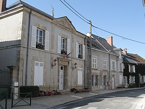
 Local government ( Mairie ) of Bou |
||
Bou is a French municipality with 958 inhabitants (as of January 1 2017) in the department of Loiret in the region Center-Val de Loire . It belongs to the Arrondissement Orléans and the Canton of Saint-Jean-de-Braye (until 2015: Canton Chécy ). The inhabitants are called Boumien (ne) s .
geography
Bou is about eight kilometers southeast of Orléans on the north bank of the Loire . Neighboring communities are Chécy in the north and north-west, Mardié in the north and north-east, Jargeau in the east and south-east and Sandillon in the south and west.
Population development
| year | 1962 | 1968 | 1975 | 1982 | 1990 | 1999 | 2006 | 2012 |
| Residents | 415 | 499 | 567 | 580 | 705 | 846 | 911 | 906 |
Attractions
- Saint-Georges church from the 11th century with renovations from the 12th and 15th centuries, since 1922/1935 partially monument historique
- Old distillery
Personalities
- Julien Palma (* 1993), track cyclist
Web links
Commons : Bou - collection of images, videos and audio files

