
Höllental (Lower Austria)

The Höllental in Lower Austria is a narrow valley through which the Schwarza flows between the steep limestone massifs Schneeberg and Rax .
It stretches over a length of 16.5 km between Schwarzau im Gebirge and Hirschwang and, due to its natural beauty, belongs to the Natura 2000 area of the Northeast Rim Alps: Hohe Wand - Schneeberg - Rax . Larger side valleys are the Weichtal , the Große Höllental (although much smaller), the Kesselgraben, the Nasswaldtal and the Voisbachtal. The course is followed by a well-developed road, the Höllentalbundesstraße (B 27) , a touring route that is particularly popular with motorcyclists. In the valley and the side valleys there are some important sources of drinking water supply (Fuchspassquelle, Kaiserbrunn and Wasseralmquelle), the water of which is directed to the Austrian capital Vienna via the 1st Vienna High Spring Water Pipeline . On the occasion of the 125th anniversary of the 1st Vienna Spring Water Pipeline, the so-called 1st Vienna Water Pipeline Path was built along the most beautiful sections of the pipeline route , which starts here as a hiking trail between Kaiserbrunn and Hirschwang. The Kaiserbrunn Water Pipe Museum provides information about the history and construction of the aqueduct as well as the water supply in Vienna .
Since the valley is a popular excursion area, there are several restaurants along the road: the Weichtalhaus at the beginning of the Weichtal and in Kaiserbrunn the Landgasthof Kaiserbrunn . The Höllental is the starting point for alpine tours on the Schneeberg and the Rax. The Schwarza is used in this area for swimming and white water kayaking and is managed as a fly fishing water .
Public transport through the Höllental is a regular bus connection from Rohr im Gebirge or Schwarzau im Gebirge to the Payerbach-Reichenau train station , which runs several times a day in both directions. In addition, the Payerbach-Hirschwang museum railway runs from the Semmering Railway to the beginning of the Höllental valley on weekends in the summer months .
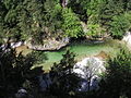
The Schwarza in Höllental

The Weichtalhaus at the beginning of the Weichtalklamm (2010)

The moated castle of the Kaiserbrunnen spring in Kaiserbrunn

The monument to the original sources of the Viennese high spring water pipeline at the entrance to the Großer Höllental


Web links
Individual evidence
- ↑ Web service of the City of Vienna: Water pipe hiking trail from Kaiserbrunn to Gloggnitz
- ^ Web service of the City of Vienna: The Kaiserbrunn Water Pipe Museum
Coordinates: 47 ° 45 ' N , 15 ° 46' E