Hörning (Breddin)
|
Hörning
Breddin municipality
Coordinates: 52 ° 51 ′ 21 ″ N , 12 ° 14 ′ 17 ″ E
|
|
|---|---|
| Height : | 26 m above sea level NHN |
| Residents : | 9 (Dec 31, 2006) |
| Postal code : | 16845 |
| Area code : | 033972 |
|
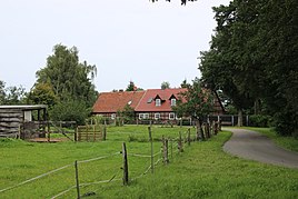
View from the south
|
|
Hörning is a dwelling place of Breddin in Ostprignitz-Ruppin in Brandenburg .
geography
The place is three kilometers south-southeast of Breddin in the district of Sophiendorf . The neighboring towns are Sophiendorf in the northeast, Lohm in the east, Voigtsbrügge in the southeast, Waldfrieden in the southwest, Kümmernitz in the west and Breddin mining in the northwest.
Web links
Commons : Hörning - collection of images, videos and audio files
- Hörning in the genealogical directory
Individual evidence
- ↑ Community and district directory. In: geobasis-bb.de. Land surveying and geographic base information Brandenburg, accessed on March 21, 2020 .
- ^ Breddin parish - inhabited parts of the parish - living spaces. In: service.brandenburg.de. Ministry of the Interior and Local Affairs of the State of Brandenburg, accessed on August 27, 2017 .
- ↑ BrandenburgViewer of the state survey and geographic base information Brandenburg (LGB)

