
Hut pond
| Hut pond | |||||||||
|---|---|---|---|---|---|---|---|---|---|
 |
|||||||||
|
|||||||||
|
|||||||||
| Coordinates | 50 ° 52 '34 " N , 13 ° 21' 33" E | ||||||||
| Data on the structure | |||||||||
| Lock type: | dam | ||||||||
| Construction time: | 1558-60 | ||||||||
| Height of the barrier structure : | 7.8 m | ||||||||
| Height above foundation level : | 8.8 m | ||||||||
| Height of the structure crown: | 446.1 m above sea level NN | ||||||||
| Crown length: | 443 m | ||||||||
| Crown width: | 8.5 m | ||||||||
| Operator: | State dam administration of Saxony | ||||||||
| Data on the reservoir | |||||||||
| Total storage space : | 0.325 million m³ | ||||||||
| Catchment area | 4.78 km² | ||||||||

The Hüttenteich (also Great Hüttenteich ) is an artificial pond created in the 16th century between Brand-Erbisdorf and Weißenborn in the Ore Mountains . It is part of the Freiberg Revierwasserlaufsanstalt . He gives his water to the Münzbach and in the past gave it to the now defunct Turmhof-Kunstgraben .
Description and function
The hut pond is the lowest reservoir in the cascade of the Revierwasserlaufanstalt, which is operated by the state dam administration. The system is used for intermediate storage and the targeted distribution of raw water for the Freiberg industry. Furthermore, it serves for flood protection, runoff regulation and the fishing industry. The bank areas are registered areas according to Art. 4 of the Fauna-Flora-Habitat Directive 93/43 / EEC.
The hut pond, which was built between 1550 and 1560, was improved by Martin Planer , along with many other existing water management systems in the Freiberg mountain area . The accumulated supply was soon no longer sufficient for the water requirements of the Münzbachhütten, which were largely built in the 16th century, and for Freiberg. Therefore, the planner tried to expand his catchment area. Since the Berthelsdorfer Hüttenteich supplied all Münzbachhütten with impact water, it is at the same time a technical monument.

View of the waterfront of the dam
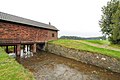
Overflow at the hut pond


Individual evidence
- ^ State dam administration of the Free State of Saxony: Description on the internet presence of the state dam administration . Retrieved June 16, 2012.
- ^ Otfried Wagenbreth : The Freiberg mining. Technical monuments and history . German publishing house for basic industry, Leipzig 1986, pp. 103, 134, 143, 252.
Web links
- State dam administration of the Free State of Saxony: Staumeisterei Revierwasserlaufanstalt Freiberg. Hut pond . on www.smul.sachsen.de.
- State dam administration of the Free State of Saxony: dams . Dams directory and map of the dams, reservoirs and flood retention basins in the Free State of Saxony, at www.umwelt.sachsen.de.