Hüttnersee
| Hüttnersee | ||
|---|---|---|

|
||
| Geographical location | Canton Zurich | |
| Tributaries | Sägelbach | |
| Drain | Krebsbach | |
| Location close to the shore | Huts , Saturdays | |
| Data | ||
| Coordinates | 693 709 / 226 558 | |
|
|
||
| Altitude above sea level | 658 m above sea level M. | |
| surface | 16.5 ha | |
| Maximum depth | 13.3 m | |
| Middle deep | 6.3 m | |
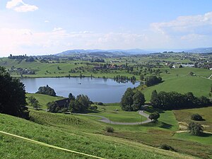
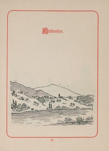
The Hüttnersee (spelling in the national map 1: 25,000 sheet 1132 from 2016 edition) also Hüttner See (official surveying) ( Swiss German: “De Hüttnersee” or “Hüttnerseeli”) is a small lake in the village of Hütten in the municipality of Wädenswil in the canton Zurich . The north and east bank with the bathing facility belongs to the village of Saturdayern in the municipality of Richterswil . The lake has a volume of 1,045 million m³, a catchment area of 2.4 km² and is located near the Itlimoosweiher (municipality of Wollerau , canton Schwyz ) and the Stauweiher Sternenweiher (municipality of Richterswil).
The water is over-fertilized by agriculture in the lake area. The lake has therefore been artificially ventilated since December 1983.
According to the oldest documented mention of August 6, 1520, the Hüttnersee was referred to as the "Bibetsee". It is said to have been very rich in fish and crabs at the time. In the middle of the 18th century this original name was gradually replaced.
Notation
In the past there were different spellings for this local name .
| Siegfried card | until 1953 | Hüttnersee |
| National map | from 1954 | Hüttner Seeli |
| National map | from 2002 | Hüttnerseeli |
| National map | from 2016 | Hüttnersee |
| Cadastral surveying | 2015 | Hüttner See |
| Cantonal overview plan | 2015 | Hüttner See |
| Topographic landscape model TLM | 2015 | Hüttnersee |
| OpenStreetMap | 2015 | Hüttnersee |
| Google Maps | 2015 | Hüttnersee |
| Former homepage of the municipality of Hütten | 2015 | Hüttnersee |
Web links
- Live image of the Hüttnersee
- Hüttnersee history, origins of the Hüttnersee etc. on huetten.ch
- Lido Hüttnersee badi-info.ch (including background information)
- Hüttnersee an enchanted place Walter Noser: Observer , dossier from October 12, 2011
- Hüttnersee or Hüttner See ? see. Duden-Online, derivation of geographical names in -er
Individual evidence
- ↑ Hüttnersee on ortsnames.ch
- ↑ Ventilation and circulation support Hüttnersee Building Directorate of the Canton of Zurich, Office for Waste, Water, Energy and Air, Department of Water Protection, notification of April 15, 2015
- ↑ Fish and crabs from Bibetsee huetten.ch , accessed on January 20, 2016
- ^ Hüttnersee in the Siegfried map
- ^ Hüttner Seeli on the national map
- ↑ Hüttnerseeli on map.geo.admin.ch
- ↑ Hüttnersee on map.geo.admin.ch
- ↑ Hüttner See in the official survey
- ↑ Hüttner See on the cantonal overview map
- ^ Hüttnersee in the TLM topographic landscape model
- ↑ Hüttnersee on OpenStreetMap
- ^ Hüttnersee on Google Maps


