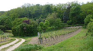
Haardtrand - Am Schlammberg
|
Haardtrand - Am Schlammberg
IUCN category none - not specified |
||
| location | Rhineland-Palatinate , Germany | |
| surface | 61 ha | |
| WDPA ID | 163434 | |
| Geographical location | 49 ° 28 ' N , 8 ° 10' E | |
|
|
||
| Setup date | 1992 | |
The Haardtrand - Am Schlammberg nature reserve is located in the Bad Dürkheim district in Rhineland-Palatinate . The approximately 61 hectare area, which was placed under nature protection in 1992 , extends on the north-western outskirts of Bad Dürkheim . The state road L 518 runs to the north, the L 517 to the east and the B 37 to the south .
The purpose of protection is
- the maintenance and development of an area characterized by a diverse pattern of use made up of vineyards of different management intensity, fruit plots, shrubbery and fringe biotopes, forest and forest edge areas, dry stone walls and vineyard terraces ,
- the preservation and development of the area as a location for rare plant species and plant communities and as a habitat for rare, sometimes threatened animal species,
- the preservation and development of the area for reasons of regional history and because of its special character.
See also
Web links
Commons : Haardtrand - Am Schlammberg (nature reserve) - Collection of pictures, videos and audio files


