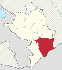
Hadrut (province)
Hadrut ( Armenian Հադրութ , also Hadrout ) is a province of the internationally not recognized Republic of Nagorno-Karabakh , the capital is Hadrut . The province was merged with the Martuni province to form Xocavənd district by the Azerbaijani parliament in the course of the official dissolution of the Nagorno-Karabakh Republic in 1991 , but this was not implemented due to the conflict . After the occupation of the southern parts of Azerbaijan by the Armenian army in 1993, the province also administered parts of the Azerbaijani district of Füzuli and the entire district of Cəbrayıl . An eastern part of the province is controlled by Azerbaijan.
The province has an area of 1876.8 square kilometers and according to the Nagorno-Karabakh census of 2005 12 005 inhabitants at 6.4 inhabitants per square kilometer. In the province there are one city, eight larger towns and 20 municipalities.
In the province are the Asych caves , in which stone-age paintings can be found.
Individual evidence
- ↑ Results of 2005 census of the Nagorno-Karabakh Republic (PDF, accessed on April 23, 2008; 131 kB)
- ↑ Results of 2005 census of the Nagorno-Karabakh Republic (PDF, English; 227 kB)
Web links
- Now the time has come for building Article by Victoria Abrahamyan (in the Internet Archive)
Coordinates: 39 ° 30 ' N , 47 ° 0' E
