
Hadsund Havn
| Hadsund Havn | |||
|---|---|---|---|
| Data | |||
| owner | Mariagerfjord Municipality | ||
| start of building | 1860 | ||
| opening | 1861 | ||
| Geographic information | |||
| place | Hadsund | ||
| region | North Jylland region | ||
| Country | Denmark | ||
 |
|||
| Coordinates | 56 ° 42 '48 " N , 10 ° 6' 48" E | ||
|
|||

Hadsund Havn , the port of the Danish city of Hadsund , is located on the north bank of the Mariagerfjord and consists of an industrial or transport port , a yacht harbor and a fishing port . The shipping and fishing ports are owned by Mariagerfjord Municipality .
Traffic port
The traffic port , the actual Hadsund Havn , was built in 1860/1861 to relieve the small ferry station. For this purpose , a ship bridge was built especially for the steamer Ydun going to Copenhagen , which until then had to take passengers from Hadsund on board via a dinghy . The name Københavnerhovedet (Copenhagen head), which is part of the western harbor, is reminiscent of the steamship service that was discontinued in 1956 . Ships with a length of 120 m and a width of 23 m can dock at the 210 m long quay . For larger yachts, there is also a 46 m long wooden pier, the Andersens Bro , available.
Marina
The yacht harbor, Hadsund Lystbådehavn , also built in 1860/1861 , is located about 550 meters west of the traffic port and is suitable for ships with a maximum length of 12 m and a width of 3 m. There are 200 berths available in the smaller and 130 × 40 m large harbor basins . The sailing club Hadsund Sejlklub, founded in 1943 during the German occupation , is the owner of the port and has its headquarters here.
Fishing port
When entering the Mariagerfjord from Kattegat, in front of the road and railway bridge built between 1902 and 1904 for the Aalborg – Hadsund line , which was replaced by a bascule bridge ( Hadsundbroen ) in 1972 , the fishing port, Hadsund Fiskerihavn (located around 800 meters east of the traffic port ) , which was created in 1937 by the Hadsund fishing association, Hadsund Fiskeriforening . The port lost its importance over time and is now mainly used as a recreational area. In front of the jetties is still the place where the nets were once mended. The facility, which consists of two harbor basins, can be used by ships with a maximum draft of 1.5 m (3 m at the outer and western piers).
Hadsund port railway

From 1928 to 1969 there was a connection to the railway network via the 513 m long Hadsund Havnebane , which branched off from the Aalborg – Hadsund railway line at Hadsund Nord station and led to the transport port ( Trafikhavn in Danish ).
After the inauguration of the Hadsundbroen in 1904, planning began for a railway line from Hadsund Nord station to the port. Engineer L. Schlegel drew the project and calculated the estimated costs in 1907. A year later, the director of Aalborg-Hadsund Jernbane pointed out that there were technical problems. The junction for the port railway would have to be laid all the way to the west at the north station, which would have exceeded the cost estimate by far. Therefore the Aalborgbane was not interested in the construction, because it was feared that the freight trains would take the shorter Randersbane south.
The building committee tried to get the additional costs of 20,000 crowns and contributions from institutions outside Hadsund were promised. After repeated requests to the craftsmen's association, planning for the port railway began in 1912. A new committee was set up for this purpose. During the First World War he had no capital for the construction, so the planning was postponed.
In 1920 the building was checked again. Hadsundbanen was not interested in building the railway for the same reason as before. In September 1920 an agreement was reached on the financing, construction and operation of the port railway based on a draft plan. The final agreement was signed on March 20, 1926 and in 1928 the sidings could be used. The plant costs 56,000 kronor, half of which was taken over by the state and Aalborg County a quarter.
photos

View from the Hadsundbroen to the traffic port
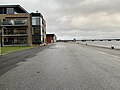
Transport harbor with the Hadsundbroen in the background

Fishing port

Course of the port railway (blue dashed) and the Randers – Hadsund railway line (red dashed)


Web links
Individual evidence
- ↑ a b Publication by Hadsund Turistforening , July 1999, text by museum inspector Lise Andersen (Danish)
- ↑ Hadsund Havn. In: Den danske Havnelods. Miljøministeriet, Geodatastyrelsen, accessed on 16 May 2016 (Danish).
- ↑ Hadsund Lystbådehavn. In: Den danske Havnelods. Miljøministeriet, Geodatastyrelsen, accessed on 16 May 2016 (Danish).
- ↑ Hadsund Lystbådehavn . Sejlnet.dk, accessed July 9, 2014 (Danish)
- ↑ Hadsund Sejlklub: Klubbens Historie , accessed on July 9, 2014 (Danish)
- ↑ Hadsund Fiskerihavn. In: Den danske Havnelods. Miljøministeriet, Geodatastyrelsen, accessed on 16 May 2016 (Danish).
- ↑ Havnebanen i Hadsund. In: Nordjyllands jernbaner. Retrieved July 9, 2014 (Danish).
- ↑ Havnebaner, Hadsund. Historical plans and pictures. In: havnebaner.dk. Retrieved July 9, 2014 (Danish).