Hamden (Connecticut)
| Hamden | ||
|---|---|---|
|
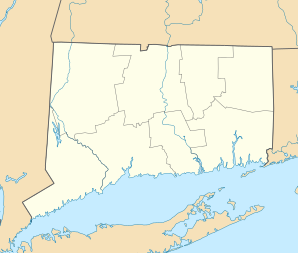
Location in Connecticut
|
||
| Basic data | ||
| Foundation : | 1786 | |
| State : | United States | |
| State : | Connecticut | |
| County : | New Haven County | |
| Coordinates : | 41 ° 24 ′ N , 72 ° 55 ′ W | |
| Time zone : | Eastern ( UTC − 5 / −4 ) | |
| Residents : | 58,180 (as of 2005) | |
| Population density : | 685.3 inhabitants per km 2 | |
| Area : | 84.9 km 2 (about 33 mi 2 ) | |
| Height : | 56 m | |
| Postcodes : | 06514, 06517, 06518 | |
| Area code : | +1 203 | |
| FIPS : | 09-35650 | |
| GNIS ID : | 0213440 | |
| Website : | www.hamden.com | |
| Mayor : | Scott Jackson | |
Hamden is a city in New Haven County in the US state of Connecticut , United States , with 59,200 inhabitants (as of 2004). The urban area has a size of 86.3 km 2 . Near the town there is a special hill formation called "Sleeping Giant" , which gave the area the nickname "The Land of the Sleeping Giant" .
history
Hamden was originally settled by Puritans as part of the city of New Haven . The land was bought by Theophilus Eaton and Reverend John Davenport in 1638 from the Quinnipiack Indian tribe living there. In 1786, by amalgamating several villages, it became a separate town, which was named after John Hampden . In the 19th and early 20th centuries there was a brisk influx of immigrants, mainly from Ireland and Italy . In the period after the Second World War, the southern part of the city was transformed into an industrial center, while the northern part kept its rural character.
schools
- Bear Path School
- Church Street School
- Dunbar Hill School
- Helen Street School
- Ridge Hill School
- Shepherd Glen School
- Spring Glen School
- West Woods School
- Hamden Middle School
- Hamden High School
- Quinnipiac University
sons and daughters of the town
- Ernest Borgnine (1917–2012), actor
- John Carpenter (born 1967), game show winner
- Matt Martin (* 1971), ice hockey player and coach
