Sleeping Giant (Connecticut)
| Sleeping giant | ||
|---|---|---|
|
View from Giant's Chin |
||
| height | 225 m | |
| location | Connecticut , USA | |
| Mountains | Metacomet Ridge | |
| Coordinates | 41 ° 25 '50 " N , 72 ° 53' 27" W | |
|
|
||
| Type | basalt | |
| Age of the rock | Triassic (geology) | |
Sleeping Giant (also: Mount Carmel ) in south-central Connecticut is a rugged basalt rock north of New Haven . It is part of the narrow Metacomet Ridge that stretches from Long Island Sound near New Haven north through the Connecticut River Valley of Massachusetts to the Vermont border. As an outstanding landmark, it got its name from the resemblance to a sleeping human form that can be recognized from the north as well as from the south. The Giant is known both for the expansive views from the height of its cliffs , as well as for its picturesque landscape and interesting microclimatic ecosystems. Most of the mountain is protected as a Sleeping Giant State Park . It is a popular recreational destination. More than 30 miles of hiking trails run through its territory, including the Quinnipiac Trail . Quinnipiac University is at the foot of Mount Carmel in Hamden .
geography
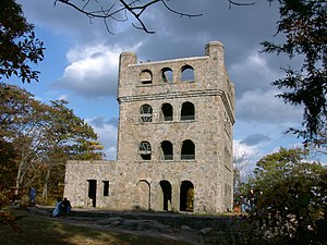
The Sleeping Giant is in the Hamden area. Its eastern end goes to Wallingford . It extends over an area of 4.43 km by 2.82 km. Seen from a distance, the "body parts" "head", "chin", "chest", "hips", "knees" and "feet" can be made out, which are represented by basalt cliffs. The highest point is the left hip at 225 m above sea level . The next height is the chest (220 m) and the left knee and right leg at 210 m. At Giant's Head (200 m) a cliff drops 120 m deep. A stone lookout tower is on the left hip. It was built by the Works Progress Administration in the 1930s . It opens up panoramic views of the surrounding Mill and Quinnipiac River valleys. An old quarry that has not been in use since the 1930s has left scars on Giants Head.
The Metacomet Ridge extends west and south of the Sleeping Giant as the Rocky Top and West Rock Ridge . The western portion of the Sleeping Giant drains into the Mill River and thence towards New Haven Harbor and Long Island Sound ; the east drains into the Quinnipiac River.
geology
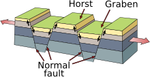
Sleeping Giant is a fractured tectonic rock ledge that formed around 200 million years ago during the Triassic and Jurassic . It consists of traprock , a type of basalt , an extrusive volcanic rock. Light earthquakes have been recorded and even reported by local residents. Basalt is dark in color, but due to its high iron content it turns a characteristic rusty brown when weathered. Basalt often breaks down into octagonal and pentagonal columns, creating characteristic "paving stones". Large scree fields of broken basalt are visible everywhere along the ledges. The basalt cliffs are the result of several large lava flows that tumbled up in faults from the earth's interior hundreds of meters below the surface as North America separated from Eurasia and Africa . These basalt pourings occurred over a period of about 20 million years. In the meantime, thick layers of sediment accumulated on the lava layers, which were gradually baked into sedimentary rock. The resulting layer of "cake" experienced warping and pushed upwards out of the surrounding rock. As a result, the softer sedimentary layers eroded faster than the hard basalt, so that the edges of the basalt cover came to light, creating the sharp ridges and picturesque cliffs that are visible today.
Ecosystem
Sleeping Giant is home to several microclimates rarely found in New England . Dry, hot rock ridges are overgrown by so-called oak savannas , which are often dominated by chestnut oak and various grasses and ferns. Virginian juniper , a drought-resistant species, clings to the edges of the cliffs. The lower eastern slopes are mostly composed of oak-hickory forests , species that are also common in the surrounding plains. Narrow gorges with dense stands of Canadian hemlocks block the sunlight and create a damp, cooler climate in which other plant species thrive. The scree slopes are particularly rich in nutrients and provide a habitat for a large number of lime-loving plants that are otherwise rare in eastern Connecticut.
The Sleeping Giant is also an important migration area for birds of prey .
history
According to Quinnipiac legends , the Sleeping Giant is actually the sleeping hobbomock, a famous vicious stone giant that appears in many stories (such as the Pocumtuck Ridge and Quinnipiac). Hobbomock was upset about the bad treatment of his people and stamped his foot in anger so that the course of the Connecticut River turned east (cf. a place in Middletown (Connecticut) where the river abruptly turns east turns). In order to prevent the evil spirit from causing further harm in the future, the good spirit enchanted Keitan Hobbomock so that he should sleep forever, at the place that still reminds of him today due to the impressive human-like shape.
In the mid- 19th century , the works of painters from the Hudson River School and transcendentalists such as Ralph Waldo Emerson and Henry David Thoreau made mountains a place of refuge from industrialization and urbanization in New England. Summer cottages were built on the Sleeping Giant and in many other locations along Metacomet Ridge. In 1888 John H. Dickerman built a carriage path on the Giant and opened Blue Hills Park . He held picnics for the residents on the cliffs. In 1924 the idea of protection began to work on the Sleeping Giant too. That year, the Sleeping Giant Park Association (SGPA) was founded by a group of local residents who were concerned about basalt mining. A vacation home owner had leased his property to the Mount Carmel Traprock Company . The demolition of beloved parts of the landscape led to public uproar, which found wide coverage in the local newspapers. Under the direction of James W. Toumey, a professor of forest science at Yale University , the SGPA had a 10-year dispute with the quarrying company. In 1933 , during the Great Depression , the site was acquired by the SGPA for $ 30,000 and declared a Sleeping Giant State Park . A full story was published in Nancy Davis Sachses book Born Among the Hills - The Sleeping Giant Story .
The Sleeping Giant Tower ( ⊙ ) was built in 1936 by the Works Progress Administration and was listed on the National Register of Historic Places in 1986 as part of the Connecticut State Park and Forest Depression-Era Federal Work Relief Programs Structures .
Recreation
|
Sleeping Giant State Park
|
|
|
Observation tower on the Sleeping Giant October, 2004 |
|
| location | Connecticut , United States |
| surface | 610 hectares |
| Setup date | 1933 |
| administration | Sleeping Giant Park Association (SPGA); State of Connecticut |
Sleeping Giant State Park is a popular recreational destination. The cliffs offer sweeping views over a large part of New Haven County and parts of Hartford County , and in good weather conditions even over Long Island Sound to Shoreham on Long Island .
Sleeping Giant is open until sunset year round; Parking costs between $ 4 and $ 10 on weekends and holidays. However, there is still parking outside the park and on hiking trails further north and east. Hiking, climbing, snowshoeing, picnicking, bird watching and other passive activities are allowed. Special routes for riders and cross-country skiing are marked in the lower areas of the Giant and fishing is permitted in the Mill River. Climbing was banned for a long time due to accidents, but was reopened in 2007. Camping for teenagers is only allowed with permission. There are some toilets and picnic areas. The Quinnipiac Trail crosses the park lengthways from the Quinnipiac River in the west over the highest points of the Giants to the Mill River and from there turns north over West Rock Ridge and Mount Sanford .
conservation
Most of the Sleeping Giant has been preserved in its original state. The trails and facilities are community maintained by the Sleeping Giant Park Association and the State of Connecticut. Sleeping Giant State Park covers 6.1 km²; The SGPA continues to try to acquire additional land and prevent deforestation and the construction of radio masts. The SGPA regularly organizes guided tours and construction projects to maintain the hiking trails. The Connecticut Forest and Park Association also supports this work with investment funds.
Literary influences
In 1948, children's author Eleanor Estes published the Sleeping Giant and Other Stories collection . In the eponymous story, the Sleeping Giant decides to get up and leave.
See also
- State Parks in Connecticut
- Metacomet Ridge
- Quinnipiac River
- Sleeping Giant (Kauai)
- Sleeping Giant (Ontario)
Individual evidence
- ^ A b Farnsworth, Elizabeth J. "Metacomet-Mattabesett Trail Natural Resource Assessment." ( Memento of the original from August 7, 2007 in the Internet Archive ) Info: The archive link was inserted automatically and has not yet been checked. Please check the original and archive link according to the instructions and then remove this notice. , 2004. PDF file. Cited Nov. 20, 2007.
- ^ Connecticut Walk Book: A Trail Guide to the Connecticut Outdoors. 17th edition. The Connecticut Forest and Park Association. Rockfall, Connecticut. Undated.
- ↑ DeLorme Topo 6.0. Mapping software. DeLorme, Yarmouth, Maine
- ↑ Raymo, Chet and Maureen E. Written in Stone: A Geologic History of the Northeastern United States . Globe Pequot, Chester, Connecticut, 1989.
- ↑ The Traprock Wilderness Recovery Strategy ( Memento of the original from August 16, 2007 in the Internet Archive ) Info: The archive link was automatically inserted and not yet checked. Please check the original and archive link according to the instructions and then remove this notice. . Cited Dec. 13, 2007
- ↑ a b c d e Sleeping Giant Park Association ( Memento of the original from May 11, 2015 in the Internet Archive ) Info: The archive link has been inserted automatically and has not yet been checked. Please check the original and archive link according to the instructions and then remove this notice. . Cited Dec. 25, 2007
- ^ Department of Environmental Protection: Parking and Camping Fees - CT State Parks and Forests
- ^ Ragged Mountain Foundation. ( Page no longer available , search in web archives )
- ^ Sleeping Giant State Park. Connecticut Department of Environmental Protection.
- ^ Connecticut Forest and Park Association . Cited Dec. 25, 2007.
Web links
- Sleeping Giant State Park Connecticut Department of Energy and Environmental Protection
- Sleeping Giant State Park Map Connecticut Department of Energy and Environmental Protection
- Sleeping Giant Park Association
- Sleeping Giant Trail Map (color) Sleeping Giant Park Association
- Sleeping Giant Trail Map (b & w) Sleeping Giant Park Association
- Sleeping Giant Cross-country Ski Trail Map Sleeping Giant Park Association


