West Rock Ridge
| West Rock Ridge | ||
|---|---|---|
|
"West Rock, New Haven" by Frederic Edwin Church , 1849 |
||
| height | 210 m | |
| location | Connecticut , USA | |
| Mountains | Metacomet Ridge | |
| Coordinates | 41 ° 24 '56 " N , 72 ° 56' 17" W | |
|
|
||
| Type | basalt | |
| Age of the rock | Triassic (geology) | |
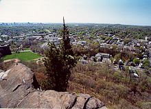
The West Rock Ridge (also: West Rock ) in the southern, central Connecticut is a 11 km (7 mi) long basalt ridge (Traprock), part of the Metacomet Ridge that extends from Long Iceland Sound in New Haven by the Connecticut River Valley by North moves across Massachusetts to Vermont . The highest point on West Rock Ridge is 210 m (700 ft) above sea level . The ridge is popular as an excursion destination and is known for its special microclimatic ecosystems , rare plant communities, and good vantage points from the cliffs that rise up to 152 m (500 ft) from the surrounding landscape.
history
The West Rock Ridge as part of the Metacomet Ridge owes its origin to the continental drift . In the Triassic and Jurassic around 200 mio. Years ago, lava oozed out of the cracks that formed when the North American and Eurasian plates drifted apart . The basalt currents were several hundred meters thick and, strictly speaking, the Metacomet Ridge is a prehistoric rift valley , which in its time was a side or parallel ditch of the Atlantic .
In the 17th century, the area became a retreat for American independence fighters. Judges' Cave and Regicides Trail got their names from the two judges, Edward Whalley and his son-in-law, William Goffe , who signed a death warrant for Charles I of England in 1649 . After the Stuart Restoration in 1660, the two Regicides fled into the mountains and hid in a grotto on the ridge of the Ridge.
In the 19th century the West Rock Ridge became a popular motif for various landscape painters such as Frederic Edwin Church (1849) or George Henry Durrie .
The General Assembly enacted an Act Concerning West Rock Ridge State Park that established a state park in 1975 when the Connecticut Department of Environmental Protection (DEP) covered 2.4 km² (600 acres) of the City of New Haven . Through this decree, the DEP has a right of first refusal on private land sales within the West Rock Ridge conservation area . This is to enable the state to enlarge the park area. The area has now grown to 6.5 km² (1600 acres).
geography
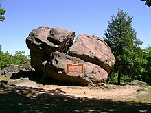
West Rock Ridge spans the boroughs of New Haven, Hamden , Woodbridge, and Bethany . It is 1.6 km (1 mi) wide at its widest point. The most significant peaks include the highest point of the Ridge, the High Rock or York Mountain , with a height of 210 m, as well as the southern tip, the West Rock or South Overlook (122 m, 400 ft), at which there is a parking lot, Picnic tables and a lookout point there. Small hills rise again and again between these two peaks. The Judges' Cave is also at the southern end of the ridge.

There are important aquifers on the West Rock Ridge . Therefore, the South Central Connecticut Regional Water Authority borders with water protection areas in the west; Reservoirs are along with others Lake Dawson and Lake Watrous . Konolds Pond is located just north of Route 15 in an industrial area. The largest body of water in the park area is Lake Wintergreen (18 ha, 44 acre) east of the ridge. There are also smaller ponds on Mountain Road and a retention basin at the north end of the park. The Wilbur Cross Parkway (Rt. 15) passes the south of the ridge through the Heroes Tunnel ( West Rock Tunnel ). Roads run on all sides of the park and a park road, which is only passable in summer, runs along the top of the ridge. Several transmission masts were placed on the hill.
To the east of West Rock Ridge run further branches of Metacomet Ridge, which show up in several low, parallel waves that run to Saltonstall Mountain in Branford ; The only notable peak in this area is East Rock , which towers north of New Haven. From the west of the ridge the waters flow through the West River into Long Island Sound; to the east the waters flow first into Belden Brook and then into the West River ; from the north they flow into the Mill River and New Haven Harbor into Long Island Sound.
geology
The West Rock Ridge was formed by fracture tectonics . An enormous dyke pushed lava flows with a thickness of several hundred meters into the tectonic rifts that occurred during the continental drift about 200 million ago. Years and about 20 mio. Passed for years. Erosion between the individual effusions formed thick layers of sediment. The "layer cake" that arose from it was later shifted again and pushed up. Further erosion washed away the sediments, leaving the lava flows as cliffs in the landscape. The ridge consists mainly of diabase , a plutonite . Diabase is dark gray, but due to its high iron content it turns rusty brown due to oxidation processes . This gives the rocks of the West Rock Ridge their characteristic reddish color. The rock often formed pentagonal or octagonal column formations, so-called "postpiles", as it cooled. Enormous gravel fields have formed below the cliffs.
ecology
Due to its shape, West Rock Ridge is home to some microclimate zones that are unusual for New England . The dry summit regions are home to Oak Savanna communities , in which the chestnut oak often dominates along with some grass and fern species. Virginian juniper (Juniperus virginiana, Eastern red cedar) clings to the dry edges of the cliffs. Further down on the eastern slopes, the vegetation changes into the widespread oak-hickory forests . Narrow canyons are populated by Canadian hemlocks (Tsuga canadensis, eastern hemlock), which shield the sunlight and create shady, moist, and cooler locations for plants that are normally found in cooler regions to grow. Hemlocks are mostly infested with hemlock mealybugs (Adelges tsugae, hemlock woolly adelgid). The debris cones are rich in nutrients and are populated by lime-loving plants. Because of these many different locations, the ridge is home to a number of threatened and endangered plant and animal species. The formation also forms an important migratory line for migratory birds of prey.
Leisure and nature conservation
West Rock Ridge is popular as a recreational area in the New Haven region , as the cliffs offer views of the Berkshires in the west, Long Island Sound and Long Island in the south, and Mount Sanford in the north. Most of the area is public land and designated as a State Park and Town Park, or conservation easement and Watershed Property. The northern slopes are partially built up. The ridge is criss-crossed by a network of hiking trails, most notably the 11 km (7 mi) long Regicides Trail and the southern portion of the 37 km (23 mi) long Quinnipiac Trail . The Quinnipiac Trail runs over the north summit and continues east over Sanford Mountain to the Sleeping Giant. Both trails are maintained by the Connecticut Forest and Park Association, a non-profit organization .
The West Rock Ridge State Park covers most of the ridge and includes the Lake Wintergreen east of the mountain. The park is open daily from 8:00 a.m. to sunset and offers opportunities for hiking, biking, fishing, boating, horse riding, picnicking, and more. Park Road to South Overlook and Judges' Cave is open from Memorial Day through the last weekend in October.
The City of New Haven owns and maintains the 17 hectare (43 acre) West Rock Nature Center on the southeast side of the mountain. The center offers various natural history education programs. The center has existed since 1946 and was listed on the State Register of Historic Places by the Connecticut Historical Commission .
The Woodbridge community maintains the Bishop Estate and the Darling House Trails , a 160 acre estate on the western slope of the mountain. The property has historic buildings, hiking trails, gardens, and bridges over the West River. It was named after Thomas Darling (1720–1789), a supporter of the American Revolution and friend of Benjamin Franklin . The hiking trails are connected to the Regicides Trail.
Individual evidence
- ^ A b c d Elizabeth J. Farnsworth, "Metacomet-Mattabesett Trail Natural Resource Assessment." ( Memento of the original from August 7, 2007 in the Internet Archive ) Info: The archive link was inserted automatically and has not yet been checked. Please check the original and archive link according to the instructions and then remove this notice. , 2004. PDF.
- ↑ a b c DeLorme Topo 6.0. Mapping software. DeLorme, Yarmouth, Maine
- ↑ a b c Connecticut Walk West. 19th edition. The Connecticut Forest and Park Association. Rockfall, Connecticut. 2006.
- ↑ http://www.cga.ct.gov/2003/act/Pa/2003PA-00131-R00HB-05793-PA.htm
- ↑ http://www.rwater.com/
- ↑ http://www.ct.gov/caes/cwp/view.asp?a=2799&q=376202
- ↑ James W. Skehan: Roadside Geology of Connecticut and Rhode Island . Mountain Press Publishing Company, Missoula, Montana 2008, ISBN 9780878425471 , pp. 173-176.
- ↑ Raymo, Chet and Maureen E. Written in Stone: A Geologic History of the Northeastern United States . Globe Pequot, Chester, Connecticut, 1989.
- ↑ The Traprock Wilderness Recovery Strategy ( Memento of the original from August 16, 2007 in the Internet Archive ) Info: The archive link was automatically inserted and not yet checked. Please check the original and archive link according to the instructions and then remove this notice. .
- ↑ West Rock Nature Center City of New Haven.
- ↑ Bishop Estate & Darling House Trails ( Memento of the original from January 1, 2011 in the Internet Archive ) Info: The archive link was inserted automatically and has not yet been checked. Please check the original and archive link according to the instructions and then remove this notice. Town of Woodbridge.


