
Hamerlingplatz
| Hamerlingplatz | |
|---|---|
|
|
|
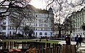
 Eastern part of Hamerlingplatz and Hamerlingpark |
|
| Basic data | |
| place | Vienna |
| District | Josefstadt |
| Created | 1904 |
| Newly designed | 1983 |
| Confluent streets | Skodagasse, Kupkagasse, Klesheimgasse |
| use | |
| User groups | Pedestrians and cyclists ; limited motorized individual traffic in the peripheral areas |
| Technical specifications | |
| Square area | about 7720 m² |
The Hamerlingplatz located in the 8th Viennese district of Josefstadt .
history
Hamerlingplatz was created on the site of the demolished Josefstadt barracks . The name was given on October 26, 1904 by the city council in honor of the poet Robert Hamerling .
Design, transport
The rectangular square is surrounded by buildings from the first years of the 20th century. The center is occupied by the Hamerlingpark with a monument to Robert Hamerling, a quiet zone, a children's playground and a dog zone . Motorized individual traffic is only possible through Skodagasse on the west side of the square; the lanes on the other sides of the square are only available to residents for entry and exit as well as cyclists.
An underground car park with 332 spaces for short-term and long-term parkers has been built under the square.
Public transport is available just 100 m away at the junction Josefstädter Straße / Albertgasse (tram lines 2, 5, 33).
Addresses
(Listed objects are highlighted in bold. Descriptions based on Dehio.)
- No. 1 : Hamerling-Hof (identity address: Albertgasse 30), a monumental apartment building on the Spitz between Albert- and Skodagasse; Architect: Carl Bittmann
- No. 2: House with partly secessionist decor
- No. 3: B-building of the former Military Geography Institute , later Cartography Institute of the Federal Office for Metrology and Surveying , today (2020) a senior citizens' residence. The mighty U-shaped block, which takes up the entire north side of the square, was built according to plans by the architects Siedeck and Stiegler. The main courtyard is closed off from Hamerlingplatz by a wrought iron grille.
- No. 4: House, architect Arthur Baron
- No. 5–6 : The Vienna Business School (Handelsakademie II) building was built from 1906 to 1907 according to plans by the architects Julius and Wunibald Deininger .
- No. 7 to 10: Representative residential buildings with partly secessionist design elements
gallery

Hamerlinghof

Hamerlingplatz 3, former Cartographic Institute

Hamerlingplatz 4

Vienna Business School (commercial academy)

South side of the Hamerlingplatz
View to Josefstädter Strasse

Hamerlingpark
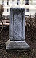
Memorial stone for Robert Hamerling


Web links
Individual evidence
- ↑ Hamerlingplatz. In: Vienna History Wiki. City of Vienna, accessed on February 16, 2020 .
- ↑ Hamerlingplatz Tiefgarage , website of the operator Best in Parking, accessed on February 17, 2020
- ↑ Bundesdenkmalamt (Ed.): Dehio-Handbuch Die Kunstdenkmäler Österreichs. Vienna II. To IX. and XX. District. Verlag Anton Schroll & Co. ISBN 3-7031-0680-8 p. 350
Coordinates: 48 ° 12 ′ 39.9 " N , 16 ° 20 ′ 43.3" E