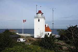
Hammerodde Fyr
| Hammerodde Fyr | ||
|---|---|---|
| Hammerodde Fyr in September 2018 | ||
| Place: |
|
|
| Location: | On the northern tip of Bornholm | |
| Geographical location: | 55 ° 17 '53.6 " N , 14 ° 46' 25.8" E | |
| Fire carrier height : | 12 m | |
| Fire height : | 21 m | |
|
|
||
| Identifier : | Fl (2) W.10s | |
| Scope knows: | 17.4 nm (32.2 km ) | |
| Optics: | Fresnel lens | |
| Operating mode: | electric | |
| Operating time: | since December 11, 1895 | |
| International ordinal number: | C 2508 | |
Hammerodde Fyr , sometimes Hammer Odde Fyr , is a lighthouse ( Danish Fyr ) in Allinge-Sandvig , on the northern tip of Bornholm .
description
The square white tower and the adjoining building for the beacon keepers were built in 1895. The construction of the beacon was necessary because the 91 m high Hammeren Fyr could often no longer be seen in high fog .
Hammerodde Fyr uses the Swedish Sandhammarens fyr to refer to Bornholmsgat , the strait between Bornholm and the southeastern cape of the Swedish coast. Hammerodde also monitors the corresponding traffic separation area. In the immediate vicinity of the lighthouse there is a reference station for the Differential Global Positioning System . She has a range of 451 nautical miles .
Older nautical charts show that the station used to be equipped with a fog horn and a marine radio beacon . However, the operation of both plants was discontinued.
See also
Web links
- Russ Rowlett: Lighthouses of Denmark: Bornholm ( English ) In: The Lighthouse Directory . University of North Carolina at Chapel Hill . Retrieved October 11, 2018.
Individual evidence
- ↑ a b Dansk Fyrliste 2018. (PDF) Søfartsstyrelsen, accessed on September 9, 2019 (Danish).
- ↑ Hammerodde lighthouse. Lighthouse pages by Anke and Jens, accessed on October 11, 2018 .

