
Allinge-Sandvig
| Allinge-Sandvig | |||||
|
|||||
| Basic data | |||||
|---|---|---|---|---|---|
| State : |
|
||||
| Region : | Hovedstaden | ||||
|
Municipality (since 2003) : |
Bornholm's regional commune | ||||
| Coordinates : | 55 ° 17 ′ N , 14 ° 48 ′ E | ||||
|
Population : (2020) |
1,491 | ||||
| Postal code : | 3770 Allinge | ||||
| Website: | www.allinge-sandvig.dk | ||||
.jpg) Map around 1900 |
|||||


Allinge-Sandvig is a place on the northern tip of the Danish island of Bornholm in the Baltic Sea . The fishing villages of Sandvig (in the north) and Allinge grew together early on. On January 1, 2020, Allinge-Sandvig had 1,491 inhabitants.
history

From around 1900 tourism became an important industry. Until 2002 the place formed with Gudhjem and some other villages the municipality Allinge-Gudhjem with an area of 154 km².

Allinge harbor

Former Allinge station

Allinge kirke

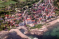
Allinge (aerial view)
Sandvig (aerial view)


.jpg)


Allinge and Sandvig were on 6 May 1913, the island's capital Ronne connected via a 31.2 km long railway track that the name Ronne allinge Jernbaneselskab A / S was wearing. At Madseløkke between Allinge and Sandvig, a route to Allingen harbor branched off. (The former rail laying in the port can still be seen in the port picture opposite.) The increasing competition from car traffic finally led to the closure of the railway line on September 15, 1953.
Attractions

There are numerous rock carvings in the area around Allinge-Sandvig . The Madsebakke rock drawings between Sandvig and Allinge date from the Bronze Age and are the largest of their kind in Denmark.
The Olskirke from the 12th century is in Olsker bei Allinge . It is one of the four round churches typical of Bornholm . In the Middle Ages it was not only important for church services , but also for defense . The loopholes on the upper floor of the church still bear witness to this today. The characteristic conical roof was added later.
On the north-west coast near Allinge are the ruins of Hammershus Castle from the 13th century. It is located on a 74 meter high rock plateau and is surrounded by a 750 meter long curtain wall.
In the vicinity of the village there are two large quarries that are well worth seeing: the “Hammeren bruddet” and the “Moseløkken sten bruddet”. There is a larger lake in the first quarry. At “Moseløkken sten bruddet” there is the “Moseløkken Stenbrudsmuseum”, which shows insights into the Bornholm quarry industry then and now. There are demonstrations in the quarry belonging to the museum.
Others
In the two large quarries belonging to the village you can climb, so there are over 100 climbing routes in “Moseløkken sten bruddet”.
Individual evidence
- ↑ a b Statistics Banks -> Befolkning og valg -> BY1: Folketal January 1st efter byområde, alder og køn (Danish)
- ^ [1] , Havnebaner: Map of Allinge / Sandvig railway line.
- ↑ The Bornholmer Eisenbahnen originally consisted of 3 separate railway companies ( Memento from January 6, 2014 in the Internet Archive ), Bornholmer Eisenbahnen.