
Hammersee (Bodenwohr)
|
Hammersee Hammerweiher |
||
|---|---|---|

|
||
| The Hammersee with Bodenwöhr (left) | ||
| Geographical location | Bodenwohr municipality , Schwandorf district , Bavaria , Germany | |
| Tributaries | Gleixnerbach, Schafgraben, Grasenbach / Pechmühlbach, Schwarzenbachl | |
| Drain | Sulzbach → Regen → Danube | |
| Places on the shore | Bodenwöhr (south bank), Blechhammer (north bank) | |
| Data | ||
| Coordinates | 49 ° 16 ′ 19 ″ N , 12 ° 18 ′ 27 ″ E | |
|
||
| Altitude above sea level | 370 m above sea level NN | |
| surface | 31 ha | |
| length | 3 km | |
| width | 100 m | |
| Maximum depth | 5 m | |
| Middle deep | 2.5 m | |
|
particularities |
Reservoir, hydropower used to be used for iron smelting |
|

The Hammersee (also: Hammerweiher ) in Bodenwöhr belongs to the Upper Palatinate Lake District and is mainly used for tourism today.
history
Bodenwöhr was first mentioned in a document in 1123. A Poto operated his mill with weir ("Potenwre", today Bodenwöhr). Ore finds in the surrounding area, also evidenced by the place name "ore houses", favored the construction of an iron hammer. Such a steelworks was relocated to Bodenwöhr before 1464, which was operated by the water power of the dammed streams from the area. The lake must have existed at that time. After the final closure of the iron and steel works in 1971, the use of the Hammersee for leisure and recreational purposes came to the fore. Today, hydropower is no longer used.
Today's use of the lake
Today there are three campsites directly on the shores of Lake Hammersee, and Bodenwöhr also has numerous accommodation options, inns, holiday apartments and guest houses. The Hammersee is rich in fish and is therefore often used by anglers. The lake can be used with boats without a motor. There are several public bathing spots on the lake, including a public bathing beach with a sandy beach and a kiosk in Bodenwöhr. For hikers and cyclists there is a circular route around the lake and many other tour options in the vicinity. The circular route is connected to the supraregional Goldsteig hiking trail .
Water quality
In the years 2011 to 2015, the lake was certified to have excellent water quality throughout the entire bathing season.
Backwaters
Smaller bodies of water are already dammed at the tributaries of the Hammersee: the Weichselbrunner Weiher (water area: around 8 ha) in the west at the Gleixnerbach and Schafgraben tributaries, the Warbrucker Weiher (water area: around 16 ha) in the east at the tributaries Grasenbach and Pechmühlbach and Schwarzenbachl. The Weichselbrunner Weiher is completely located in the 107 hectare nature reserve Weichselbrunner Weiher and dry pine forest near Bodenwöhr.
photos

View from the north bank over the Hammersee

Memorial stone on the north bank
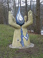
Art and water path on the Hammersee
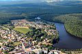
Aerial view of the Hammersee (2013)


Web links
Individual evidence
- ↑ a b District Office Schwandorf: Bathing water profile Hammersee Blechhammer . Online at www.landkreis-schwandorf.de. Retrieved December 30, 2015.
- ↑ a b District Office Schwandorf: Bathing water profile Hammersee Seewinkl . Online at www.landkreis-schwandorf.de. Retrieved December 30, 2015.
- ↑ Municipality of Bodenwöhr: local history ( memento of the original dated December 30, 2015 in the Internet Archive ) Info: The archive link was inserted automatically and has not yet been checked. Please check the original and archive link according to the instructions and then remove this notice. . Online at www.bodenwoehr.de. Retrieved December 30, 2015.
- ↑ seen.de: Facts Hammersee . Online at www.seen.de. Retrieved December 30, 2015.
- ↑ District Office Schwandorf: Water quality Hammersee Bodenwöhr . Online at www.landkreis-schwandorf.de. Retrieved December 30, 2015.