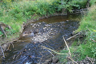
Harlebach
| Harlebach | ||
|
The Harlebach |
||
| Data | ||
| Water code | DE : 278232 | |
| location | North Rhine-Westphalia , Germany | |
| River system | Rhine | |
| Drain over | Alme → Lippe → Rhine → North Sea | |
| source | On the eastern flank of Allenberg 51 ° 27 ′ 28 ″ N , 8 ° 32 ′ 41 ″ E |
|
| Source height | 414 m above sea level NN | |
| muzzle | Southeast of Harth Coordinates: 51 ° 29 ′ 19 ″ N , 8 ° 35 ′ 39 ″ E 51 ° 29 ′ 19 ″ N , 8 ° 35 ′ 39 ″ E |
|
| Mouth height | 273 m above sea level NN | |
| Height difference | 141 m | |
| Bottom slope | 18 ‰ | |
| length | 7.7 km | |
| Catchment area | 8.961 km² | |
| Right tributaries | Almesiepen | |
The Harlebach is a 7.7 kilometers long, left tributary of the Alme in North Rhine-Westphalia , Germany .
geography
The branched source stream system of the Harlebach rises at a height of 430 meters in the area of the city of Brilon . Some of the spring rivers get their water from swampy alder and birch forests. In the lower reaches of the Harlebach forms the border between the Paderborn district and the Hochsauerlandkreis and finally flows into the Alme within the Almetal extension nature reserve . Even the source to the nature reserve Almetal extension is in the nature reserve donkeys break / Harlebachsystem . The Harlebach flows exclusively through wooded areas along its entire length.
