Hattarvík
Hattarvík [ ˈhatːaɹvʊik ] ( Danish : Hattervig ) is the easternmost place in the Faroe Islands on the island of Fugloy , which is one of the six northern islands . The place belongs to the Faroese municipality Fugloy ( Fugloyar kommuna ). At the beginning of 2016, thirteen people lived in Hattarvík. The zip code is FO-767.
The place
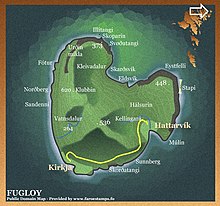
Hattarvík is located on the southeast coast of the small island of Fugloy in a bay. The place and the village of Kirkja on the southwest coast are the only two places on the island. The bay of Hattarvík is enclosed on three sides by mountains. The bay itself is rocky and sloping and therefore does not form a particularly favorable natural harbor.
The Kellingará flows through Hattarvík and flows into the bay here. The place is divided into two districts, Niðri í Húsi and Uppi í Húsi .
Hattarvík was founded in the Faroe Islands around 900 during the Viking Age . The place appears in written sources for the first time between 1350 and 1400; in the so-called dog letter . The place is also listed in the royal inventory ( Jarðarbókin ) of 1584. According to tradition, the men Hálvdan Úlvsson, Høgni Nev and Rógvi Skel lived here in the 15th century. They are called the Flokksmenn (party men) and wanted to seize power over the Faroe Islands. They were allegedly overwhelmed in the then unconsecrated church of Svínoy and subsequently sentenced to death by falling from the highest Valaknúkur. The Valaknúkar are located on the eastern bank of the Skálafjørður between Skálabotnur and Skipanes or Søldarfjørður on Eysturoy. There they are said to be buried down at the foot of the highest mountain, at a place called "við ytra Tingstein".
The current village church dates from 1899. The first church was consecrated in 1833, but 50 years later it was structurally so bad that it had to be declared in 1898 as dilapidated. Since at least 1932 there has also been a post office in Hattarvík.
The permanent residents who still live in the village today are all older men over 60. The small town is therefore specifically threatened with depopulation .
Travel and hiking conditions
Once or twice a day, the Ritan ferry to Hvannasund on the island of Viðoy runs here if necessary and if the weather permits . The Atlantic Airways helicopter flies to the place three times a week, connecting it with Klaksvík and Tórshavn . Hattarvík is connected by a small road to the second town on the island, Kirkja in the south.
A hiking trail runs parallel to this on the southeast coast. To the north is the Klubbin mountain (620 m), which is relatively easy to climb despite the lack of a path. From there there is a good view of Viðoy with its mighty Cape Enniberg . To the northeast of the village is the free-standing Stapin cliff with the 448-meter-high Eystfelli peak . The cliff is also the most easterly point of the Faroe Islands.
There are no regular overnight accommodations in Hattarvík, only a holiday home in the neighboring village of Kirkja. Anyone planning a stay beyond the day trip should check with the Kunningarstova of the North Islands in Klaksvík before leaving .
Famous pepole
- Árni Dahl and Marianna Debes Dahl , a Faroese writer and publisher couple who built a house in Hattarvík. The two spent many years there working on their books.
Web links
- Fugloyar kommuna , fugloy.fo - Fugloy municipality website (under construction).
- Faroeislands.dk - Hattarvík
- Hattarvík, photo 2010/07/14. Retrieved August 2, 2015 .
- SSL.fo - ferry line 58 (Hvannasund - Svínoy - Kirkja - Hattarvík)
- Atlantic.fo - helicopter flight plan
- Uppistovugarður , uppistovugardur.fo - the easternmost farm in the Faroe Islands
Individual evidence
- ↑ Fólkatalsbroytingar skiftar á fødd, deyð, flutt og bygd, mánaðarliga (1985-2016) , hagstova.fo
- ↑ Árni Dahl: Símun í Uppistovu í Hattarvík níti. , on page 4 in: Norðlýsið No. 1, January 10, 2014
- ↑ Hvussu gomul er bygdin , heimabeiti.fo
- ↑ Hattarvík is listed on page 12 under the Danish name "Hatteruigh": " Jarðarbókin 1584 "
- ↑ a b Floksmenn , snar.fo (in Faroese)
- ^ Jóan Pauli Joensen : Í kjalarvørri floksmanna. To mat og máltíð. Orð søgd á floksmannadegi í Hattarvík July 2, 2015. , jn.fo, July 12, 2016 (in Faroese)
- ↑ Kambsdalur - Skálafjørður , on page 6 in: "Til gongu í Føroyum", edited by Ferðaráð Føroya . (in Faroese)
- ↑ Nøvn í haganum "Norðara-parti" á Eiðissíðuni , Dagblaðið No. 86 of November 4, 1949
- ↑ Hattarvíkar Kirkja . folkakirkjan.fo. Archived from the original on May 2, 2004. Retrieved October 9, 2016.
- ↑ Fugloy , fugloy.fo
- ↑ Samferðsla , fugloy.fo
- ↑ Myndasavn , fugloy.fo - In the foreground a view of the steep wall of Stapin, the easternmost cliff in the Faroe Islands. On the right in the picture the north end of the cliff with the summit Eystfelli .
- ↑ Norðoya Kunningarstova , visitnordoy.fo
- ↑ Árni Dahl: Símun í Uppistovu í Hattarvík níti. , utoyggj.fo
Coordinates: 62 ° 20 ′ N , 6 ° 16 ′ W


