
Heard (island)
| Heard | ||
|---|---|---|
 |
||
| Waters | Indian Ocean | |
| Archipelago | Heard and McDonald Islands | |
| Geographical location | 53 ° 6 ′ S , 73 ° 30 ′ E | |
|
||
| length | 40 km | |
| width | 26 km | |
| surface | 368 km² | |
| Highest elevation |
Big Ben (Mawson Peak) 2745 m |
|
| Residents | uninhabited | |
 |
||

The island of Heard is located in the southern Indian Ocean about 430 kilometers southeast of the Kerguelen and 1500 kilometers north of East Antarctica . Together with some offshore islets (including Shag Island ) and the McDonald Islands 43 kilometers to the west, it forms the Australian outer area of Heard and McDonald Islands .
geography
Heard is a sub-Antarctic double island , consisting of two circular regions connected only by a short and narrow isthmus . The central area of the island has a diameter of 25 kilometers and is 70% covered with ice. It is almost completely occupied by the glaciated mountain range of Big Ben with the 2745 meter high Mawson Peak volcano . To the east, the 7 km long Elephant Spit spit leads into the open sea and ends at Spit Point .
Laurens Peninsula
The Laurens Peninsula forms the northwestern part of the island and is oval in shape, about nine kilometers long and five kilometers wide. It essentially consists of the Mount Dixon volcano , the highest point ( Anzac Peak ) of which is 715 meters above sea level. It is only connected to the much larger southeastern central area of Heard Island by a narrow and a few hundred meters long isthmus, which is joined by Atlas Cove from the north and West Bay from the south . Cape Laurens forms the northwestern extension of the peninsula.
history
The island was sighted on November 25, 1853 by the American captain John Heard from aboard his ship Oriental . It was not until 1855 landed sealers on the island to Tran of numerous there slain seals to capture. In 1880 the seal population was almost completely wiped out.
The island initially claimed by Great Britain was placed under Australian control in 1947 . From 1947 to 1955 there was a small Australian research station of the Australian National Antarctic Research Expeditions at Atlas Cove .
The island was added to the UNESCO World Heritage List in 1997 and is part of the Australian Heard Island and McDonald Islands Marine Reserve, established in 2002 .
Picture gallery

Heard Island (before 1900)

Heard Island (before 1900)

Mawson Antarctic Expedition (1929)

Heard Island (2007)

Heard Island (2007)
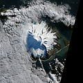
Satellite image (2012)


_(6173425701).jpg)


Web links
- Heard Island & McDonald Islands. Official website. Australian Government - Department of the Environment and Energy - Australian Antarctic Division (English).
- Heard Island & McDonald Islands ( Memento from September 2, 2012 in the Internet Archive ) in the island encyclopedia oceandots.com (English).
- CIA World Factbook: Heard Island and McDonald Islands (English).
- Heard in the Global Volcanism Program at the Smithsonian Institution .
Individual evidence
- ↑ a b General Map. (PDF; 606 kB) Map of the island of Heard. In: Heard Island & McDonald Islands. Official website. Australian Government - Department of the Environment and Energy - Australian Antarctic Division , accessed June 27, 2020 .
- ^ Discovery. In: Heard Island & McDonald Islands. Official website. Australian Government - Department of the Environment and Energy - Australian Antarctic Division , accessed October 7, 2016 .
- ↑ Australian research expeditions. In: Heard Island & McDonald Islands. Official website. Australian Government - Department of the Environment and Energy - Australian Antarctic Division , accessed October 7, 2016 .