
Heiligenhoven
|
Heiligenhoven
municipality Lindlar
Coordinates: 51 ° 0 ′ 36 ″ N , 7 ° 21 ′ 28 ″ E
|
|
|---|---|
| Height : | 191–201 m above sea level NN |
| Postal code : | 51789 |
| Area code : | 02266 |


Heiligenhoven is a historical collective name for the districts of Unter- , Mittel- and Oberheiligenhoven in the municipality of Lindlar in the Oberbergischer Kreis in the administrative district of Cologne in North Rhine-Westphalia ( Germany ).
Location and description
The three places are in the valley of the Lennef stream . While Oberheiligenhoven is located southwest of Lindlar and has grown together with the town center in terms of urban development, Mittel- and Unterheiligenhoven are further to the south.
history
In 1413, Heiligenhoven is mentioned for the first time in a combing register of Fronhof Lindlar with the name "Heiligenhoeven" . As recently as 1715, several farms in the Lennefe Valley were uniformly referred to as Heiligenhoven on the Topographia Ducatus Montani . With the topographical survey of the Rhineland map from 1825, the farms have their own names.
Sights of the three places
- LVR open-air museum Lindlar
- Heiligenhoven Castle
- Unterheiligenhoven castle ruins
- Trinity Chapel in the vicinity of the Unterheiligenhoven castle ruins
Individual evidence
- ^ Klaus Pampus: First documentary mentions of Oberbergischer places. Gummersbach 1998, ISBN 3-88265-206-3 .
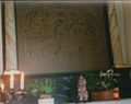
Altar image of the Trinity Chapel
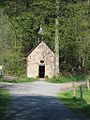
Trinity Chapel Unterheiligenhoven
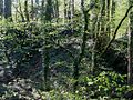
Unterheiligenhoven castle ruins


