
Unterheiligenhoven
|
Unterheiligenhoven
municipality Lindlar
Coordinates: 51 ° 0 ′ 24 ″ N , 7 ° 21 ′ 15 ″ E
|
||
|---|---|---|
| Height : | 195 m above sea level NN | |
| Postal code : | 51789 | |
| Area code : | 02266 | |
Location of Unterheiligenhoven in Lindlar |
||
 View of Unterheiligenhoven
|
||

Unterheiligenhoven is a place in the municipality of Lindlar , Oberbergischer Kreis in the administrative district of Cologne in North Rhine-Westphalia ( Germany ).
Location and description
Unterheiligenhoven is located in the southwest of Lindlar in the valley of the Lennefer Bach , at the mouth of the Vossbrucher Bach and on the road 299. The neighboring towns are Klespe , Berg , Scheller , Steinscheid and Weiersbach . The places Ober- , Mittel- and Oberheiligenhoven are named with the common place name Heiligenhoven, although they are not in close proximity to each other.
history
In 1413, Heiligenhoven is mentioned for the first time in a combing register of Fronhof Lindlar with the name "Heiligenhoeven" . The Unterheiligenhoven castle ruins are still clearly visible today. It dates from the 15th century. At this castle, the Trinity Chapel from 1705 is located directly on a hiking trail ("Um den Berg").
In 1932 the towns of Unterheiligenhoven, Klespe , Berg , Stolzenbach , Ellersbach and Wüstenhof were to be supplied with electricity by the Overath electricity cooperative, according to the council decision of the Lindlar community council.
Attractions
- The Unterheiligenhoven castle ruins
- The Trinity Chapel in the immediate vicinity of the castle ruins
- That in the neighboring Upper Heiligenhoven situated Castle Heiligenhoven
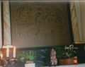
Altar image of the Trinity Chapel
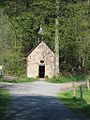
Trinity Chapel Unterheiligenhoven
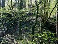
Unterheiligenhoven castle ruins


Individual evidence
- ↑ Topographical Information Management TIM-online, provided by the Cologne District Government
- ^ Klaus Pampus: First documentary naming of Oberbergischer places (= contributions to Oberbergischen history. Sonderbd. 1). Oberbergische Department 1924 eV of the Bergisches Geschichtsverein, Gummersbach 1998, ISBN 3-88265-206-3 .

Abraham Valley | Altenhof | Altenlinde | Altenrath | Mountain | Mountain cottage | Berghausen | Böhl | Bolzenbach | Bomerich | Bonnersüng | Brandsheide | Breun | Brochhagen ( upper , middle and lower Brochhagen ) | Break | Brückerhof | Buchholz | Castle | Dassiefen | Diepenbach | Dörl | Dutztal | Ebbinghausen | Eibach | Eibachhof | Eichholz | Ellersbach | Duck | Hermitage | Flag | Falkenhof ( front and rear falconry ) | Fenke | Fish depths | Frangenberg | Women's shelter | Frielingsdorf | Georghausen | Hamming | Hartegasse | House plot | Heibach | Heiligenhoven ( upper , middle and lower Heiligenhoven ) | Light | Herkenhähn | Hinterrübach | Hönighausen | Hoffstadt | Hohbusch | Hohkeppel | Holl | Holl | Wood | Hommerich | Horpe | Kaiserau | Lime kiln | Kaltenborn | Kapellensüng | Karlsthal | Merchant summer | Kemmerich | Kepplermühle | Cherry tree | Hermitage | Clasp | Kleuelshöhe | Köttingen | Krähenhof | Krähsiefen | Kuhlbach | Kurtenbach | Clay court | Leienhöhe | Lenneferberg | Lennefermühle | Linden tree | Lingenbach | Löhe | Löhsüng | Loxsteeg | Merlenbach | Mittelbreidenbach | Mittelsteinbach | Müllemich | Müllerhof | Miller's summer | Neuenfeld | Niederhabbach | Oberbergscheid | Oberbilstein | Oberbreidenbach | Oberbüschem | Oberfeld | Oberfrielinghausen | Oberhabbach | Oberhürholz | Oberkotten | Oberleppe | Oberlichtinghagen | Oberschümmerich | Aspic | Obersteinbach | Ohl | Orbach | Pothoff | Quabach ( Ober- and Unterquabach ) | Rehbach | Remshagen | Reudenbach | Roderwiese | Rölenommer | Treasure mill | Scheel | Scheelermühle | Scheller | Scheurenhof | Schlürscheid | Key Mountain | Schmitzhöhe | Schneppensiefen | Schönenborn | Schwarzenbach ( Ober- and Unterschwarzenbach ) | Siebensiefen | Sieferhof | Speak | Quarry stone | Stone bridge | Steinscheid | Stelberg | Stolzenbach | Stoppenbach | Süttenbach | Tannenhof | Scarves | Shore | Unterbergscheid | Sub-bushes | Unterbreidenbach | Subfield | Unterfrielinghausen | Unterhürholz | Lower scots | Unterlichtinghagen | Lower summer | Significance | Unterschümmerich II | Untersteinbach | Brace | Vellingen | Vorderrübach | Vossbruch | Forest break | Waldheim | Wallerscheid | Weiersbach | White horse | Welzen | Welzerberg | Weyer | Wiedfeld | Wilhelmshöhe | Wurtscheid | Desert farm | Fence
Desolations: Dillstein | Eibacher hammer | Felsenthal | Horn | Josefsthal | Luttersiefen | Meisewinkel | Estimation depths