Frielingsdorf
|
Frielingsdorf
municipality Lindlar
Coordinates: 51 ° 2 ′ 43 " N , 7 ° 25 ′ 37" E
|
||
|---|---|---|
| Height : | 242 m | |
| Postal code : | 51789 | |
| Area code : | 02266 | |
|
Location of Frielingsdorf in Lindlar |
||
|
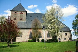
St. Apollinaris in Frielingsdorf
|
||
The Kirchdorf Frielingsdorf is a district of the municipality of Lindlar in the Oberbergischer Kreis in the administrative district of Cologne in North Rhine-Westphalia ( Germany ).
Location and description
Frielingsdorf is located about 6 kilometers east of Lindlar on state road 302 between Wipperfürth and Engelskirchen .
The Lindlarer Sülz stream flows northwest of Frielingsdorf and the Scheelbach stream flows to the east.
history
In 1490 the place was mentioned for the first time in Lindlar church accounts. The spelling of the first mention was Frylixdorf .
The Topographia Ducatus Montani by Erich Philipp Ploennies , Blatt Amt Steinbach , shows that the residential area had several farms as early as 1715, which are labeled as Frilingsdorf and referred to as a village without a church. Carl Friedrich von Wiebeking names the court on his charter of the Duchy of Berg in 1789 as Frilingdorf . It shows that at that time the place was part of the Breun community in the upper parish of Lindlar.
In 1797 a chapel was consecrated to St. Apollinaris. In 1801 it was separated from the Lindlar parish, which was lifted a little later. Finally in 1812 the final separation, with the strong commitment of Pastor Johann Peter Ommerborn . A church built in 1848-50 burned down in 1897 after being struck by lightning. 1898 New construction of the church under Pastor Matthias Schmitz. On Boxing Day 1926, parts of the church ceiling collapsed. The current church was built by Dominikus Böhm in 1927/28 . The former secondary school in Frielingsdorf was dissolved, so that there is only one elementary school in Frielingsdorf today.
The place is recorded on the topographical survey of the Rhineland from 1825 as Frilingsdorf . The Prussian first recording from 1840 shows the residential area under the name Frielingsdorf . From the Prussian new admission of 1894/96, the place is regularly recorded as Frielingsdorf on measuring table sheets .
In 1822, 98 people lived in the village, which was categorized as a courtyard and church, and after the collapse of the Napoleonic administration and its replacement, it belonged to the Lindlar mayor in the Wipperfürth district . For the year 1830 a parish church with 98 inhabitants is given for the place called Frielingsdorf . The place, which was categorized as a church village in 1845 according to the overview of the government district of Cologne , had at that time 13 residential buildings with 113 inhabitants, all of them Catholic denominations.
The municipality and estate district statistics of the Rhine province lists Frielingsdorf in 1871 with 21 houses and 103 inhabitants. In the municipality lexicon for the province of Rhineland from 1888, 13 houses with 113 inhabitants are given for Frielingsdorf . In 1895 the place had 29 houses with 197 inhabitants and belonged denominationally to the Protestant parish Hülsenbusch and the Catholic parish Frielingsdorf, in 1905 36 houses and 297 inhabitants are given.
Attractions
- cenotaph
Infrastructure
- Catholic parish of St. Apollinaris Frielingsdorf in the listed St. Apollinaris Church
- Community elementary school Frielingsdorf
Web links
Individual evidence
- ^ Klaus Pampus: First documentary naming of Oberbergischer places (= contributions to Oberbergischen history. Sonderbd. 1). Oberbergische Department 1924 eV of the Bergisches Geschichtsverein, Gummersbach 1998, ISBN 3-88265-206-3 .
- ^ Wilhelm Fabricius : Explanations for the Historical Atlas of the Rhine Province ; Second volume: The map of 1789. Division and development of the territories from 1600 to 1794 ; Bonn; 1898
- ↑ Alexander A. Mützell: New topographical-statistical-geographical dictionary of the Prussian state . tape 1 . Karl August Künnel, Halle 1821.
- ↑ Friedrich von Restorff : Topographical-statistical description of the Royal Prussian Rhine Province , Nicolai, Berlin and Stettin 1830
- ↑ Overview of the components and list of all the localities and individually named properties of the government district of Cologne: by districts, mayor's offices and parishes, with information on the number of people and the residential buildings, as well as the Confessions, Jurisdictions, Military and former state conditions. / ed. from the Royal Government of Cologne [Cologne], [1845]
- ↑ Royal Statistical Bureau Prussia (ed.): The communities and manor districts of the Prussian state and their population . The Rhine Province, No. XI . Berlin 1874.
- ↑ Königliches Statistisches Bureau (Prussia) (Ed.): Community encyclopedia for the Rhineland Province, based on the materials of the census of December 1, 1885 and other official sources, (Community encyclopedia for the Kingdom of Prussia, Volume XII), Berlin 1888.
- ↑ Königliches Statistisches Bureau (Prussia) (Ed.): Community encyclopedia for the Rhineland Province, based on the materials of the census of December 1, 1895 and other official sources, (Community encyclopedia for the Kingdom of Prussia, Volume XII), Berlin 1897.
- ↑ Königliches Statistisches Bureau (Prussia) (Ed.): Community encyclopedia for the Rhineland Province, based on the materials of the census of December 1, 1905 and other official sources, (Community encyclopedia for the Kingdom of Prussia, Volume XII), Berlin 1909.


