Altenlinde
|
Altenlinde
municipality Lindlar
Coordinates: 51 ° 1 ′ 37 ″ N , 7 ° 21 ′ 48 ″ E
|
||
|---|---|---|
| Height : | 237 m above sea level NN | |
| Postal code : | 51789 | |
| Area code : | 02266 | |
|
Location of Altenlinde in Lindlar |
||
|
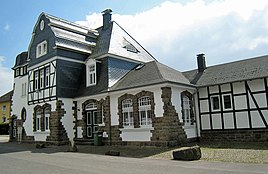
Lindlar railway station
|
||
Altenlinde is a place in the municipality of Lindlar in the Oberbergischer Kreis in the administrative district of Cologne in North Rhine-Westphalia ( Germany ).
Location and description
The place is in the northwest of Lindlar. The development of Lindlar has grown to the local limits of Altenlinde. Neighboring towns are Lindlar, Schwarzenbach , Schätzmühle , Untersülze and Abrahamstal .
history
On the map Topographical Survey of the Rhineland from 1825, Altenlinde is shown on two enclosed courtyards with nine separate building floor plans and named "Linde".
In the Prussian first recording from 1840 the place name is "Alte Linde". The place name Altenlinde has been used in topographic maps since 1894/96. After 1962, the independent place name Altenlinde is no longer available in the topographic maps. The name of the street leading through the town is " Altenlinde ".
In 1822 ten people lived in the place categorized as a courtyard, which after the collapse of the Napoleonic administration and its replacement belonged to the Lindlar mayor in the Wipperfürth district . For the year 1830 eleven inhabitants are given for the place called Alte Linde . The town, which was categorized as a hamlet and designated Altelinde , according to the survey of the government district of Cologne in 1845 , had five residential buildings with 45 inhabitants at that time, all of which were Catholic.
The municipality and estate district statistics of the Rhine Province lists Altenlinde in 1871 with seven houses and 52 inhabitants. In the municipality lexicon for the Rhineland province from 1888, seven houses with 52 inhabitants are given for Altenlinde . In 1895 the place had eight houses with 75 inhabitants, in 1905 eight houses and 64 inhabitants are given.
The track systems of the Lindlar station, which went into operation in 1912, extended along the outskirts of Altenlinde. The station was the terminus of the Cologne-Mülheim-Lindlar railway line . In 1966 the section between Lindlar and Hopesthal was closed and dismantled. In 2013, the “ Bahnhofstrasse ” and the path name “ Am Bahndamm ”, as well as the former train station and the structure of the water tower, are reminiscent of the railway past .
bus connections
Altenlinde is connected to local public transport via the local bus stop for lines 332 and 335.
Individual evidence
- ↑ a b c Topographic Information Management TIM-online, provided by the Cologne District Government
- ^ Historika25, State Surveying Office NRW, sheet 4910, Lindlar
- ↑ Alexander A. Mützell: New topographical-statistical-geographical dictionary of the Prussian state . tape 3 . Karl August Künnel, Halle 1822.
- ↑ Friedrich von Restorff : Topographical-statistical description of the Royal Prussian Rhine Province , Nicolai, Berlin and Stettin 1830
- ↑ Overview of the components and list of all the localities and individually named properties of the government district of Cologne: by districts, mayor's offices and parishes, with information on the number of people and the residential buildings, as well as the Confessions, Jurisdictions, Military and former state conditions. / ed. from the Royal Government of Cologne [Cologne], [1845]
- ↑ Royal Statistical Bureau Prussia (ed.): The communities and manor districts of the Prussian state and their population . The Rhine Province, No. XI . Berlin 1874.
- ↑ Königliches Statistisches Bureau (Prussia) (Ed.): Community encyclopedia for the Rhineland Province, based on the materials of the census of December 1, 1885 and other official sources, (Community encyclopedia for the Kingdom of Prussia, Volume XII), Berlin 1888.
- ↑ Königliches Statistisches Bureau (Prussia) (Ed.): Community encyclopedia for the Rhineland Province, based on the materials of the census of December 1, 1895 and other official sources, (Community encyclopedia for the Kingdom of Prussia, Volume XII), Berlin 1897.
- ↑ Königliches Statistisches Bureau (Prussia) (Ed.): Community encyclopedia for the Rhineland Province, based on the materials of the census of December 1, 1905 and other official sources, (Community encyclopedia for the Kingdom of Prussia, Volume XII), Berlin 1909.
- ↑ Busnetz 2013, Oberbergischer Kreis, published by Verkehrsverbund Rhein-Sieg GmbH


