
Unterheiligenhoven Castle
| Unterheiligenhoven Castle | ||
|---|---|---|
 Unterheiligenhoven castle ruins |
||
| Creation time : | around 1400 to 1500 | |
| Conservation status: | ruin | |
| Place: | Unterheiligenhoven | |
| Geographical location | 51 ° 0 '23.9 " N , 7 ° 21' 12.8" E | |
| Height: | 220 m above sea level NN | |
|
||

The ruins of Unterheiligenhoven Castle are located near Unterheiligenhoven , Lindlar in the Oberbergisches Land in North Rhine-Westphalia .
location
The castle ruins are bordered to the north and east by ponds that are fed by the Lenneferbach. There is a courtyard to the west of the ruin and the Trinity Chapel to the northeast. A watermill once stood at the confluence of the Vossbrucher and Lenneferbach rivers.
history
The main castle dates from the 15th , the outer castle from the 17th century . The Niederheiligenhovener feudal and court court met here. The castle was accessed via a bridge towards the outer bailey. The south-eastern part of the castle did not collapse until 1929. The Trinity Chapel dates from 1705.
investment
The double walls of the castle are still clearly visible in the area, but have largely crumbled. The outer bailey is surrounded by its own, artificially raised ring wall. Storm Kyrill in January 2007 toppled a tree, which further affected the ruins of the ruins. The ruin is on private property and is not accessible.
photos
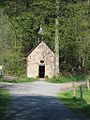
Trinity Chapel Unterheiligenhoven
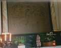
Altar image of the Trinity Chapel


See also

Alsbach Castle | Bellinghausen Castle | Bieberstein Castle | Denklingen Castle | Ehreshoven Castle | Eibach Castle | Georghausen Castle | Gimborn Castle | Heiligenhoven Castle | Homburg Castle | Hückeswagen Castle | House Ley | House Lützinghausen | Neuenberg Castle | Sotterbach Castle | Unterheiligenhoven Castle | Volperhausen Castle