Helligdomsklipperne
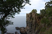
Helligdomsklipperne ( Holy Cliffs ) are a group of cliffs on the island of Bornholm . They are located about 5 km from Gudhjem and about 5 km from Tejn . They are characterized by about 22 meter high cliffs made of sharp granite . The name of the cliffs originated in the Middle Ages when there was a sacred spring near the coast, which attracted pilgrims, especially at Saint Hans Aften ( Midsummer Festival ). During the last ice age, a large part of today's coast was below sea level, since the ice melt it has been around 20 meters above sea level. Cliffs with deep caves and towering granite columns are typical of this area of the coast. In the southeast the Kyststi (coastal path) runs to the well-preserved Døndalen . Helligdomsklipperne are a popular tourist attraction, which is approached by tourist boats from Gudhjem in the summer months.
history
The area's “sacred” character emerged in the Middle Ages when a chapel called Trefoldighedskapellet (Trinity Chapel ) stood in the field right in front of the cliffs. At the foot of the cliffs there was a spring of holy water, which was brought to the chapel and, according to legend, was supposed to cure people from all diseases, especially when drunk on midsummer night. According to a report from 1806, describes how little water was in the spring that a woman was asked to replenish it with seawater.
In 1906, when tourism was developing on Bornholm, the Hotel Helligdommen was bought by a German along with a stretch of land along the coast. The resentment of the population quickly led to the establishment of Foreningen Bornholm , which demanded public access to the coastal path along the cliffs. In 1911, the association built the nearby Bornholmerpladsen in order to be able to accommodate the increasing number of visitors.
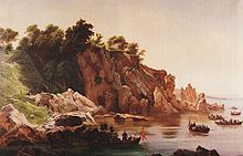
The Helligdomsklipperne have long been an attraction for both visitors and artists, such as B. documents Anders Christian Lunde's painting of King Frederik VII's arrival by ship in 1851.
Geology and rock formations
The origins of the rocks go back 1.7 billion years. Made of striped gneiss , they are criss-crossed by an abundance of small diabase canals. These created cracks that were later filled with additional magma and diabase. Some parts of the subsurface turned out to be more environmentally resistant than others, which resulted in the rugged effects that are visible today. Since the last ice age, the sea level has been significantly higher at times, so that the rocks were completely covered by water several times. The different depths of channels and “ovens” in the cliffs are a result of water erosion.
The varieties Gryde (Black Pot), Våde Ovn (Wet Oven) and Tørre Ovn (Dry Oven) reach deep into the cliffs. At the northwestern end of the formation are the Libertsklippen , named after the landscape painter Georg Emil Libert (1820–1908), who devoted himself to these rocks with particular interest. The name of the Lyseklippen (candle cliffs), initially called Lysene (candles) or Alterlysene (altar candles), goes back to the time when there were two cliffs that rose into the sky in the shape of candles. However, one of them was washed away in a storm in the early 19th century. The names of the other rock formations Kærlighedsbænken (love bank ), Mågetårnet (seagull tower) and Måneskinsklipperne (moonlight cliffs) seem to date from the late 19th century when tourists discovered the site. The Black Pot is a special tourist attraction because it is possible to penetrate about 60 meters deep into the rock.
flora
Different types of mountain ash stand on the cliffs. Rowan trees stand next to the rock whitebeam . This has led to the spread of the Finnish whitebeam ( Sorbus hybrida group ) and the Swedish whitebeam . In addition, heather , carnation , oak , birch and juniper grow there . The winter linden begins to replace the diseased elms on the Helligdomsklipperne. Even Norway maple trees grow there.
Individual evidence
- ↑ Helligdomsklipperne. (No longer available online.) Bornholmerguiden.dk, archived from the original on 23 September 2015 ; Retrieved January 24, 2013 .
- ↑ Andrew Stone, Carolyn Bain, Michael Booth, Fran Parnell: Denmark . Lonely Planet, 2008, ISBN 978-3-8297-1616-1 , pp. 20 ( Google Books [accessed January 24, 2013]).
- ↑ a b Lone Mouritsen, Roger Norum, Caroline Osborne: The Rough Guide to Denmark . Rough Guides, 2010, ISBN 978-1-84836-517-9 , pp. 149 ( Google Books [accessed January 24, 2013]).
- ↑ Helligdomsklipperne. The Danske store , accessed January 24, 2013 .
- ↑ Helligdomsklipperne på Bornholm. (No longer available online.) Bornholmerguiden , archived from the original on September 23, 2015 ; Retrieved January 24, 2013 .
- ↑ Fodor's (Ed.): Fodor's Denmark: the guide for all budgets, completely updated, with many maps and travel tips . 2002, ISBN 978-0-676-90201-3 ( Google Books [accessed January 24, 2013]).
- ↑ a b c d e Helligdommen - Helligdomsklipperne - På 367 ture in Bornholms natur. Retrieved January 24, 2013 .
- ^ Hans Steenstrup Holbeck: "Kongebesøget på Bornholm 1851". (No longer available online.) Bornholms Historiske Samfund , formerly in the original ; Retrieved January 24, 2013 . ( Page no longer available , search in web archives ) Info: The link was automatically marked as defective. Please check the link according to the instructions and then remove this notice.
Web links
Coordinates: 55 ° 13 ′ 23 " N , 14 ° 53 ′ 40" E


