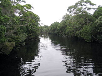
Henty River
| Henty River | ||
|
Henty River |
||
| Data | ||
| location | Tasmania ( Australia ) | |
| River system | Henty River | |
| Drain over | Henty River → Indian Ocean | |
| source |
Mount Tyndall 41 ° 55 ′ 7 ″ S , 145 ° 32 ′ 39 ″ E |
|
| Source height | 264 m | |
| muzzle |
Southern Ocean in the Henty Dunes between Strahan and Zeehan Coordinates: 42 ° 2 ′ 46 " S , 145 ° 14 ′ 43" E 42 ° 2 ′ 46 " S , 145 ° 14 ′ 43" E |
|
| Mouth height | 0 m | |
| Height difference | 264 m | |
| Bottom slope | 5.8 ‰ | |
| length | 45.5 km | |
| Left tributaries | Newton Creek, Ewart Creek, Malcom Creek, Bottle Creek, McCutcheons Creek, Badger River | |
| Right tributaries | Dobson Creek, Yolande River , Tully River | |
The Henty River is a river in the west of the Australian state of Tasmania , west of the West Coast Range .
geography
River course
The river arises west of Mount Tyndall on Anthony Road (B28) from Dobson Creek and Newton Creek . He accompanies the road south to its confluence with the Zeehan Highway , which it crosses west of this confluence. At the confluence of the Yolande River , the Henty River turns west. Shortly before reaching the coast, he passes under the Henty Road (B27) and enters the Henty Dunes . There it flows into the Indian Ocean .
The upper reaches of the river, on which the Henty Gold Mine is located, was one of the last to be regulated by Hydro Tasmania .
Tributaries with mouth heights
- Dobson Creek - 264 m
- Newton Creek - 264 m
- Ewart Creek - 89 m
- Malcom Creek - 52 m
- Yolande River - 50 m
- Bottle Creek - 37 m
- McCutcheons Creek - 32 m
- Lost Creek - 21 m
- Tully River - 10 m
- Badger River - 6 m
Recreational facilities
In October and November, the Henty River is considered good fishing water for trout on their way to the sea. There are picnic spots by the Zeehan Highway Bridge and Henty Road.
literature
- Geoffrey Blainey: The Peaks of Lyell , 6th Edition. Edition, St. David's Park Publishing, Hobart 2000, ISBN 0-7246-2265-9 .
- Charles Whitham: Western Tasmania: A Land of Riches and Beauty.
Web links
Individual evidence
- ↑ a b c d Map of Henty River, TAS . Bonzle.com
- ^ Steve Parish: Australian Touring Atlas . Steve Parish Publishing, Archerfield QLD 2007. ISBN 978-1-74193-232-4 . Pp. 58 + 60
