Hirschenstein (Saxony)
| Deer stone | ||
|---|---|---|
| height | 610.4 m | |
| location | Free State of Saxony , Germany | |
| Mountains | Ore Mountains | |
| Coordinates | 50 ° 35 '35 " N , 12 ° 34' 21" E | |
|
|
||
| particularities | highest mountain in the district of Zwickau | |
The Hirschenstein is a mountain in the Saxon Ore Mountains about 4 kilometers west of Schneeberg . It is located in the district of Hartmannsdorf in the Hartmannsdorfer Forest . At the summit there is a historical station of the royal Saxon triangulation .
history
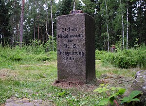
Even before the settlement by the Franks, the summit was known to the Sorbs as Recma . In 1864 land surveyors erected a granite column with the inscription "Station Hirschenstein of the Royal Saxon Triangulation".
In 1940/41 a wooden, 60 meter high tower was built above the survey point, which was also used as a lookout tower. However, 10 years later the stability of the construction was no longer guaranteed and it was removed.
From 1964 the Hartmannsdorfer Forest surrounding the summit became a restricted military area. Only since the dissolution of the Schneeberg Mountain Hunter Battalion in March 2008 has the 1,600 hectare forest area been freely accessible again.
additional
The Hirschenstein is the highest point in the Zwickau district .
Web links
Individual evidence
- ↑ a b c freiepresse.de The highest mountain in the district has no observation tower ( memento of the original from January 7, 2010 in the web archive archive.today ) Info: The archive link has been inserted automatically and has not yet been checked. Please check the original and archive link according to the instructions and then remove this notice. , accessed December 4, 2009

