
Hochhausen (Haßmersheim)
|
Hochhausen
Local community Haßmersheim
|
|
|---|---|
.svg) |
|
| Height : | 160 m |
| Residents : | 776 (Dec. 31, 2018) |
| Incorporation : | January 1, 1972 |
| Postal code : | 74855 |
| Area code : | 06261 |
Hochhausen is on Neckar village situated in Neckar-Odenwald , which since 1972 to Haßmersheim belongs.
history


Hochhausen emerged from a Franconian royal estate and was first mentioned on May 26, 788 under document no. 2457 of the Lorsch Codex . An “Emehilt” gave away a riding school and twelve acres of land in Hochhausen, among other places. The first settlement took place much earlier, however, as the remains of a Roman villa rustica , a farm yard belonging to the Neckar-Odenwald-Limes , were found in Hochhausen . Around 950 the ownership of the court property passed to the Weißenburg monastery, at the same time a basilica in Hochhausen is mentioned for the first time, which, according to a legend, was built in honor of Notburga von Hochhausen , who was supposedly buried there in the 7th century .
In the 12th century there were about 25 houses in the village next to the church. In 1259 the diocese of Speyer acquired the place and around 1300 gave the Horneck von Hornberg as a fief. They later built the castle of the place and through them the place, which settled along the Kailbach valley, was reformed in the 16th century. Due to the building structure of the old town (numerous simple houses without stables) it is assumed that a large part of the residents were day laborers to the manor. The Kailbach, now largely ruined, drove one or more mills.
In 1734 the lordship of the place died out with the lords of Hornberg and Hochhausen fell to their Bavarian Catholic line, which led to religious disputes about the place, which was ultimately returned to the bishop of Speyer. Between 1743 and 1753 the gentlemen von Helmstatt acquired the place and in 1770 built the Hochhausener Castle on the remains of the former castle, which was to become the ancestral seat of the Hochhausener line of the family. Baron Damian Hugo von Helmstatt issued ordinances in 1756 on the compulsory service of subjects and on shipping on the Neckar.
In 1806 Hochhausen came to the Grand Duchy of Baden after the regional principalities were mediatized . In 1815 a Catholic chapel was built. From 1855 there was a cigar factory, in 1888 a gypsum factory was opened, which had its tunnels on the boundary of Obrigheim.
In 1930 Hochhausen had 434 inhabitants, in 1939 there were 383 inhabitants, at the end of 1945 there were 454. In 1952 the Finkenhof was incorporated. At the. January 1, 1972 was incorporated into Haßmersheim. Today (as of 2018) Hochhausen has 776 inhabitants.
coat of arms
Blazon : in silver a black raven with spread wings . The raven is the heraldic animal of the Lords of Helmstatt.
Attractions


- The high Hausen Castle was built in 1770 by Damian Hugo von Helmstatt built and later by his descendants Raban of Helmstatt extended to the great hall to its present form.
- The Notburgakirche Hochhausen in its present form dates back to the 14th century. The church, which has been rebuilt several times, has numerous art treasures, in addition to the Notburga grave with the plastic representation of the local saints, a historical winged altar as well as ornate colored medieval grave slabs.
- To the northwest of Hochhausen are the former Hochhausen vineyards, which are now designated as a nature reserve. Finkenhof , a historic farm estate, which came into the possession of Franz Ludwig von Helmstatt (1752–1841) in 1812 , whose grave pyramid , erected in 1844, is located in a wood above the estate, is located further northwest on the Karlsberg plateau .
- The Notburga cave on the banks of the Neckar south-east of the village is a scene of the Notburga legend.

Hist. Truss

Village fountain 1895

Helmstatt grave pyramid
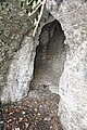
Notburga cave


Notburga of Hochhausen
Notburga von Hochhausen is a regional legendary figure, around whom several legends entwine and to whom the local church is dedicated.
Web links
Individual evidence
- ^ Community website Haßmersheim
- ↑ Communications from the Württ. And Bad. State Statistical Office No. 2: Results of the population census on December 31, 1945 in North Baden
- ^ Federal Statistical Office (ed.): Historical municipality directory for the Federal Republic of Germany. Name, border and key number changes in municipalities, counties and administrative districts from May 27, 1970 to December 31, 1982 . W. Kohlhammer, Stuttgart / Mainz 1983, ISBN 3-17-003263-1 , p. 477 .