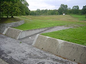
Luhne-Lengefeld flood retention basin
| Luhne-Lengefeld flood retention basin | |||||
|---|---|---|---|---|---|
| Flood overflow | |||||
|
|||||
|
|
|||||
| Coordinates | 51 ° 15 '9 " N , 10 ° 25' 10" E | ||||
| Data on the structure | |||||
| Construction time: | 1951-1955 | ||||
| Height above valley floor: | 11.4 m | ||||
| Height above foundation level : | 13.6 m | ||||
| Height of the structure crown: | 252.2 m | ||||
| Building volume: | 60 000 m³ | ||||
| Crown length: | 280 m | ||||
| Crown width: | 3 m | ||||
| Slope slope on the air side : | 1: 2.25-1: 2.75 | ||||
| Slope slope on the water side : | 1: 3.00 - 1: 3.75 | ||||
| Data on the reservoir | |||||
| Altitude (at congestion destination ) | 250.31 m | ||||
| Water surface | 16 ha | ||||
| Storage space | 680 000 m³ | ||||
| Total storage space : | 800,000 m³ | ||||
| Catchment area | 36.8 km² | ||||
| Design flood : | 70 m³ / s | ||||
The Luhne-Lengefeld flood retention basin is a dam in northwest Thuringia between Mühlhausen and Lengefeld . The water from the Luhne is held back in the normally empty basin during high tide .
The dam was built from 1951 to 1953 and the entire system was commissioned in 1955. It is an earth dam that is divided into three zones. It has a berm on the water side and on the air side . The dam is sealed from the subsurface with a spur and a sealing curtain (injection curtain). The building site consists of shell limestone, marl limestone, clay, boulder clay, shale and limestone.
The operating facilities include an inlet structure , a gravity tunnel , a slide shaft in the middle of the dam with two slide valves , a stilling basin and a flood relief system .
See also
literature
- Dams in Thuringia, Thuringian dam administration, author college, 1993
Web links
- Thuringian Fernwasser - Dams of the operation center ( Memento from March 3, 2009 in the Internet Archive )

