Hohen Sprenzer See
| Hohen Sprenzer See | ||
|---|---|---|

|
||
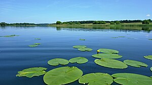
| View over the lake from the south | ||
| Geographical location | Rostock district | |
| Tributaries | smaller streams and ditches | |
| Drain | Mühlbach zur Nebel | |
| Places on the shore | Hohen Sprenz , Dudinghausen, Friedrichshof | |
| Data | ||
| Coordinates | 53 ° 55 '12 " N , 12 ° 12' 51" E | |
|
|
||
| Altitude above sea level | 22.9 m above sea level NHN | |
| surface | 2.25 km² | |
| length | 2.8 km | |
| width | 1.3 km | |
| volume | 15,780,000 m³ | |
| Maximum depth | 17.3 m | |
| Middle deep | 7.0 m | |
| PH value | 8.6 | |
| Catchment area | 11.9 km² | |
The Hohe Sprenzer See is located between the towns of Schwaan and Laage , about 22 kilometers from Rostock . The area is characterized by a hilly ground moraine landscape. In the west of the lake is the eponymous place Hohen Sprenz and in the south the place Dudinghausen. In the north is the Dolgener district Friedrichshof on the shore. The lake is around 2.8 kilometers long and 1.3 kilometers wide with an average depth of seven meters. The body of water consists of a large central basin with several smaller islands and two distinctive elongated bays in the northeast and southwest. The lake is almost completely surrounded by a forest belt. It lies in the conservation area Dolgener and High Sprenzer lake . In the northeast, Autobahn 19 runs past the lakeshore, and the Rostock-Laage airport begins two kilometers to the east .
Fish stocks
The following fish species are found in the Hohe Sprenzer See: eel , perch , pike , carp , roach , rudd , pikeperch .
