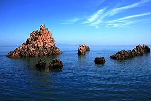
Hongdo (Yellow Sea)
| Hongdo | ||
|---|---|---|
| Hongdo Rock Islands ( 홍도 ) | ||
| Waters | Yellow Sea | |
| Geographical location | 34 ° 41 ′ 32 " N , 125 ° 11 ′ 58" E | |
|
|
||
| length | 6.4 km | |
| width | 2.4 km | |
| surface | 6.87 km² | |
| Highest elevation | Gitdaebong ( 깃대봉 ) 368 m |
|
| Korean spelling | |
|---|---|
| Korean alphabet : | 홍도 |
| Hanja : | 紅 島 |
| Revised Romanization : | Hongdo |
| McCune-Reischauer : | Hongto |
Hongdo ( Korean 홍도 ), called "Red Island" from Chinese, is an island in Jeollanam-do Province ( 전라남도 ) off the southwest coast of South Korea .
geography
The island, which actually consists of the main island and around 20 smaller rocky islands, is located around 110 km west of Mokpo ( 목포시 ), west of the islands in the Yellow Sea off the south-west of the Korean peninsula , which is called Hwanghae ( 황해 ) in South Korea . The island has an area of 6.87 km 2 and extends over 6.4 km in a south-southwest-north-northeast direction. At its widest point, the island measures around 2.4 km and its coastline comes to a total of 20.8 km. The highest point on the island is the Gitdaebong ( 깃대봉 ) with 368 m .
The Heuksando ( 흑산도 ) archipelago borders around 15 km to the east and the Heuksangundo ( 흑산 군도 ) archipelago around 25 km south-southeast . One kilometer northwest of the northern tip of the island there are around a dozen offshore rocky islands, as well as around the southern peninsula of the island. On the island itself there are two settlements, one in the north on the west coast with a small sheltered harbor and a larger one in the south on the isthmus to the peninsula to the south. The settlement has access to both sides of the coast, the western one with a small jetty and the eastern one with a sheltered harbor, where the ferries dock after a two and a half hour cruise from Mokpo.
geology
The entire island consists of reddish-brown quartz rock, which shimmers in a shade of red in the evening sun.
Administrative structure
The island is administratively organized together with the Heuksando archipelago and the Heuksangundo archipelago in the rural municipality of Heuksan-myeon ( 흑산면 ), which, together with the rural municipalities of the other islands in the region, belongs to the county of Sinan-gun, ( 신안군 ) which belongs to the province of Jeollanam-do , is managed.
Flora and fauna
270 different plant species and 170 different animal species have been located on the island.
Dadohaehaesang National Park
In 1965 the island was declared a Valuable Area and in 1981 it was part of the Dadohaehaesang National Park ( 다도해 해상 국립 공원 ). Locals and visitors are therefore only allowed to stay in the settlements and on the paths and areas designated for tourists. Likewise, no plants or even stones may be taken from the island as souvenirs.
tourism
The island offers charming landscapes, especially in the sunny evenings. The government has officially designated around 33 scenes.
Web links
- Hongdo Island ( 홍도 ). In: Visit Korea . Korea Tourism Organization,accessed November 26, 2017.
- Korean National Parks-Dadohae Haesang National Park ( 다도해 해상 국립 공원 ). (Video 4:28 min) In: Youtube . Ariang Kulture, March 23, 2015,accessed on November 26, 2017(in English, the film covers Hongdo Island from 0:50 min to 3:13 min).
Individual evidence
- ↑ a b c d Hongdo Island ( 홍도 ). In: Visit Korea . Korea Tourism Organization , accessed November 26, 2017 .
- ↑ a b c 전국 안내 지도 . 우성 지도 , Seoul 1999, ISBN 89-85762-10-9 , pp. 21 ( National Guide Map ).
- ↑ a b c Hiking Course - Hongdo Course . In: Visit Korea . Korea National Park Service , accessed November 26, 2017 .
- ↑ Coordinates and longitudes were partly made using Google Earth Pro version 7.3.0.3832 on November 26, 2017.

