Hood Canal
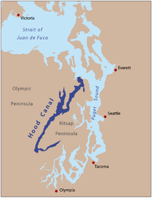
The Hood Canal is located in the US state of Washington , west of the city of Seattle and is a fjord-like branch of the Puget Sound that separates the Kitsap Peninsula from the Olympic Peninsula .
geography
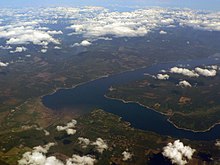
The Hood Canal is partly in Kitsap County , Mason County and Jefferson County . It begins at Port Gamble between Foulweather Bluff and Tala Point . The 112 km long Hood Canal is only 1.5 miles wide and 53.8 m deep on average. It has a 342 km long shoreline, a water surface of 385 km² and along its banks over 42 km² of mudflats. It has several bays - the largest of which is Dabob Bay in the northern part of the Hood Canal, which is separated from it by the Toandos Peninsula . The Hood Canal runs over 80 km southwest to Union , where it bends sharply northeast at the "Great Bend" section. The Hood Canal runs another 15 miles to Belfair , where it ends in a flat mudflat known as Lynch Cove . The tidal range in the Hood Canal is up to 5.5 meters.
From the Olympic Peninsula, the Skokomish River , Hamma Hamma River , Duckabush River , Dosewallips River and Big Quilcene River flow into the Hood Canal, from the Kitsap Peninsula only smaller rivers such as the Union River , Tahuya River and the Dewatto River .
history
The Hood Canal, like the Puget Sound, was formed around 13,000 years ago during the last Ice Age. The Twana called him Twana's Saltwater . It was given its current name on May 13, 1792 by George Vancouver in honor of the British Admiral Samuel Hood . Vancouver also used the name Hood Channel until the United States Board of Geographic Names made the name Hood Canal the official name in 1932.
Plants and structures
The inland traffic on the Hood Canal was initially opened up by water. US Highway 101 runs along the west bank as a central access road. On the east bank is located in Bangor Naval Base Naval Base Kitsap .
Hood Canal Bridge
At the northern end, the Hood Canal Bridge , the third longest floating bridge in the world with a length of 1988 m , crosses the fjord and connects the Kitsap with the Olympic Peninsula. Officially opened in 1961, the bridge is called William A. Bugge Bridge , named after William A. Bugge, who was the director of the Department of Highways when the bridge was built. However, the bridge is commonly called the Hood Canal Bridge. The Washington State Road 104 crosses the bridge with a retractable bridge is provided constructed opening to ships to allow access to the Kitsap Naval Base. The construction as a floating bridge was already criticized during the construction. On February 13, 1979, the western half of the float sank during a storm with gusts of wind up to 193 km / h. Because the bridge was closed because of the storm, there were no deaths or injuries. The missing part was rebuilt October 25, 1982 the renewed bridge was reopened. The eastern half of the bridge was replaced in 2009.
Parks and protected areas
The State Parks of Belfair , Twanoh , Potlatch , Triton Cove , Scenic Beach , Dosewallips , Kitsap Memorial and Shine Tidelands are located along Hood Canal .
literature
Travel Olympic National Park: travel guide and maps (Mobi Travel), electronic resource. Mobile Reference, January 2010, ISBN 978-1-60501027-4
Web links
- General Maps: Jefferson County - Kitsap County - Mason County
- Explore the Hood Canal tourism portal with numerous tips on nature and attractions
- Hood Canal in the Geographic Names Information System of the United States Geological Survey
Coordinates: 47 ° 48 ′ 0 ″ N , 122 ° 42 ′ 0 ″ W.

