
Horbergbahn
| Horbergbahn | |
|---|---|
 | |
| Location: |
Schwendau , Austria |
| Design type: | 8- MGD |
| Construction year: | 2000 |
| Mountain: | Horberg |
| Valley station: | Schwendau , 620 m. |
| Mountain station: | Horbergtal , 1645 m. |
| Height difference: | 1025 m |
| Route length: | 3837 m |
| Driving time: | 10.7 min |
| Driving speed: | 6 m / s |
| Number of gondolas: | 126 pcs. |
| Number of supports: | 24 pcs. |
| Capacity: | 2600 people / hour |
| Manufacturer: | Doppelmayr |
| Operator: | Mayrhofner Bergbahnen Aktiengesellschaft |
| Website: | www.mayrhofner-bergbahnen.com |
| Remarks: | Should have a middle station |

The Horbergbahn is a four-kilometer-long cable car in the Tux Alps that leads from the bottom of the Zillertal valley to the Zillertal 3000 ski area .
Technical specifications
The Horbergbahn is a so-called monocable gondola with cabins that can carry eight people. The valley station of the railway is at an altitude of 630 meters, its mountain station is 1656 meters high. The Horbergbahn does not have a middle station. The distance between the valley and mountain stations is almost 3840 meters. On the steepest incline, it has a gradient of 72 percent. The max. Conveying capacity is 2600 people per hour.
Valley run
The Mayrhofner Bergbahnen , under pressure from the community of Schwendau , are planning to convert 58% of an existing ski route into a ski slope with snow-making equipment, and the Horbergbahn is to have a middle station. The communities of Schwendau, Hippach and Mayrhofen , as well as the Mayrhofen-Hippach Tourist Association, are demanding that the existing ski route be converted into a ski slope up to the Horbergbahn valley station. Josef Reiter, board member of the Mayrhofner Bergbahnen, says against the expansion that the lower part of the ski route has an incline of more than 50% in some cases and is therefore not manageable for ⅔ of the skiers , there are also moral concerns with regard to the valley run on the Ahorn that have already been killed. The mayor of the community of Schwendau said: "If Josef Reiter has moral concerns, he should close the Harakiri, Austria's steepest slope." The community also mentions the safety aspect, “In good snow conditions, around 2000 winter sports enthusiasts go down to the valley on the current ski route every day. And there were no deaths ”.
history
The Horbergbahn runs on a route section of an earlier material ropeway . This 9.2 kilometer long cable car was used to transport the material extracted from the Tux magnesite mine and ran over the Hoarberg to Bühel , a district of the municipality of Ramsau in the Zillertal . The loading station on the Zillertal Railway was located there, which was then used to transport the magnesite extracted . The material ropeway was built between 1924 and 1926, but lost its function after the magnesite mine was shut down in 1976 and was later dismantled. The first Horbergbahn, a 4-person monocable gondola, and the current Horbergbahn, an 8-person EUB, were built on its route in 1982. The remains of the foundations of the former material ropeway can still be seen between the pillars.
photos
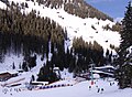
The mountain station of the railway in the Hoarberg valley

literature
- Freytag & Berndt-Verlag Vienna, hiking map 1: 50,000, sheet WK 151, Zillertal, Tux Alps, Jenbach-Schwaz . ISBN 978-3-85084-751-3
Web links
- The Horbergbahn on Bergbahn.de
- The Horbergbahn on Lift-World.info
- Magnesite mine Tux - mining and metallurgy in the Zillertal
Individual evidence
- ↑ https://www.tt.com/artikel/15832672/schwendau-bekommen-2021-eine-halbe-talabfahrt Schwendau will get a "half valley run" in 2021 . In: Tiroler Tageszeitung. Accessed April 8, 2020
- ↑ https://www.tt.com/artikel/16460014/wenn-region-die-talabfahrt-will-muss-sie-mitzahlen "If the region wants the valley run, it has to pay." In: Tiroler Tageszeitung. Accessed April 8, 2020
Coordinates: 47 ° 11 ' N , 11 ° 51' E