Horn (Limburg)
 flag |
 coat of arms |
| province |
|
| local community |
|
|
Area - land - water |
9.3 km 2 9.2 km 2 0.1 km 2 |
| Residents | 3,760 (Jan 1, 2018) |
| Coordinates | 51 ° 13 ' N , 5 ° 57' E |
| Important traffic route |
|
| prefix | 0475 |
| Postcodes | 6081, 6085, 6088, 6095, 6099 |
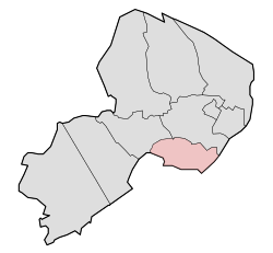
| Location of Horn in the municipality of Leudal | |
Horn is a church village in the municipality of Leudal in the Dutch province of Limburg . It is located on the Maas bank on the left bank of the Meuse , opposite Roermond on the Maas bridge on the motorway-like national road N280 . Horn has 3,760 inhabitants (as of January 1, 2018).
Horn is an old settlement that was mentioned as Hurne as early as 1102 . The spellings Hurnen , Hornin and Horne are known from the same century . The name probably goes back to the Germanic Hornjôn , which describes an elevation in a boggy landscape. In the 15th century, Horn was a county that included a large part of what is now the municipality of Leudal.
The most famous building in the area is Horn Castle , which dates back to the 10th or 11th century and originally served robber barons who collected customs from shipping on the Meuse. The castle is still inhabited by a family who bought it in 1789.
Web links
- Website of the municipality of Leudal (Dutch, English)
Individual evidence
- ↑ a b Kerncijfers wijken en buurten 2018 Centraal Bureau voor de Statistiek , accessed on August 1, 2018 (Dutch)

