Hossa National Park
|
Hossa National Park
|
||
|
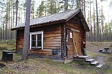
Entrance area of the Hossa Nature Park (2007) |
||
| location | Finland | |
| surface | 110 km² | |
| WDPA ID | 555633109 | |
| Geographical location | 65 ° 29 ′ N , 29 ° 19 ′ E | |
|
|
||
| Setup date | 2017 | |
| administration | Metahallitus | |
The Finnish Hossa National Park is located in the northern part of the municipality of Suomussalmi , west of the settlement of Hossa . It is the 40th national park in Finland.
The national park, which was established on the occasion of the 100th anniversary of the independent state of Finland, was opened on June 17, 2017 by the President of the Republic of Finland Sauli Niinistö .
history
The establishment of a new national park was one of the most important projects of Prime Minister Juha Sipilä . The Hossa Nature Park was chosen as National Park of the Year because Suomussalmi played an important role at the beginning of independent Finland .
Before the National Park was founded, Hossa was a state hiking area. Hossa has many lakes and good fishing opportunities, and there are a number of tourist companies here. The hiking area was founded in 1979 with a total area of 90 km². Like other areas maintained by the state forest administration ( Finnish Metsähallitus ), Hossa was not a real nature reserve. Although it is part of Natura 2000 , about a third of its forests have been felled by Metsähallitus . In December 2011, extensive deforestation plans in southwestern Hossa sparked resistance from tourist and nature conservation organizations in the region.
In January 2016, Hossa , Moilasenvaara and Julma-Ölkky were presented for the nomination as a national park on the occasion of the 100th anniversary of Finland. The reason for choosing this region was, among other things, that this area was historically important for Finland's independence and the fact that leisure and camping facilities are already in place to secure the region's economy and employment. The national park status is therefore intended to strengthen tourism in the region.
nature
The national park covers an area of around 11,000 hectares that are state-owned. The core of the national park is the approximately 9000 hectare Hossa nature park , plus parts of the Kalevala Park and the Fennoscandian green zone ( Finnish Fennoskandian vihreä vyöhyke ).
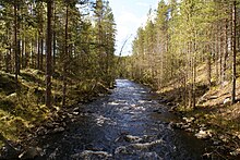
The area of Hossa is characterized by small clear rivers and around 130 lakes, supplemented by moor areas. The forests are predominantly pine forests, in which cranberries and blueberries and mushrooms grow.
Moilasenvaara, on the other hand, is characterized by primeval forest, which has a special protective value. Julma-Ölkky with Finland's largest canyon lake with its steep walls is an impressive two billion year old natural monument. Its length is about three kilometers, the width at the narrowest point about 10 m, its depth 50 m and the height of the cliffs at the highest point about 50 m. Colored human and animal figures from ancient times can be found on vertical rock walls.
There are many reindeer and deer in the area, as well as a few bears.
Road network
Around 90 kilometers of hiking trails have been marked in the park that run along the banks of the rivers and lakes. These form loops that are separated by different colored markings. There is a three-kilometer nature trail near the visitor center that presents nature, history and culture. There are also four mountain bike trails and three paths that can be used with wheelchairs. The national UKK hiking trail named after President Urho Kaleva Kekkonen leads through the park to Kylmäluoma.
From the national road 5 from can Peranga be achieved through the 9.5 km long connection path. From the northwest corner of the hiking area by Lake Somerjärvi , a 30 km long connecting route leads to the hiking area Kylmäluoma . On the way, you have to cross the Irnijärvi , through which boat transports are organized. The place Hossa is the end point of the 160 km long east border hiking trail ( Finnish Itärajan retkeilyreitin ) from Vartius .
Hossa has good fishing, the lakes are great for paddling and rowing, and the rapids are relatively easy.
Tourist center
There is a visitor center as a point of contact for tourists. In addition to an advice center, the center has a café-restaurant, an exhibition area and a shop with souvenirs and basic groceries. The center also operates the Karhunkainalon campsite, where fishing and hunting equipment, snowmobiles, boats, bicycles and camping equipment are sold and rented.
The Hossa National Park has a total of 14 open roof houses and five shelters. Tents can be set up in certain places.
Attractions
The rock painting of Värikallio is located in Kainuu. The rock painting is the third largest figure in Finland and was probably painted in the Stone Age. The painting was found in 1977 by Juha Rossi and Leena Mäkelä in the almost uninhabited area.
There are herds of reindeer in the area, and Lisää Lounatkoskesta is an old, working water mill.
literature
- Lippo Vester: Juuret selkosessa: Suomussalmen Hossan ja Selkoskylän kyläkirja. Selkosten kyläseura 1999, ISBN 951-98269-0-4 .
Web links
- Hossan kansallispuisto - Suomi100-kansallispuisto vuonna 2017. In: luontoon.fi. Metsähallitus, accessed November 6, 2017 (Finnish).
- Hossan vesireitit. In: luontoon.fi. Metsähallitus, accessed November 6, 2017 (Finnish).
- Hossan retkeilyalueen hakkuut ja talvitie 2011. (Photos). November 30, 2011, accessed November 6, 2017 .
- Valokuvia Hossasta. Retrieved November 6, 2017 (Finnish).
Individual evidence
- ↑ Hossan kansallispuisto avataan itsenäisyyden juhlavuoden kunniaksi. Ilta Sanomat, June 17, 2017, accessed November 6, 2017 (Finnish).
- ↑ Antti Kettumäki: vuoden retkeilykohteeseen suunnitellaan hakkuita. In: www.yle.fi. YLE Kainuu, December 2, 2011, archived from the original on August 22, 2013 ; Retrieved November 6, 2017 (Finnish).
- ↑ a b Itsenäisyyden juhlavuoden kansallipuisto Suomussalmen Hossaan. In: Valtioneuvosto / Statsrådet / Finnish Government. valtioneuvosto.fi, January 14, 2016, accessed November 6, 2017 (Finnish).
- ↑ Julma Ölkky - Suomen suurin kanjonijärvi. Julma Ölkky, Kuusamo, accessed November 6, 2017 (Finnish).
- ↑ Hossan Pyöräilyreitit. In: Luontoon.fi. Metsähallitus, accessed November 6, 2017 (Finnish).
- ↑ Etene esteettä Hossassa. In: Luontoon.fi. Metsähallitus, accessed November 6, 2017 (Finnish).
- ↑ Tervetuloa Itärajan retkeilyreitin ystävien joukkoon! itarajanreitti.fi, accessed November 6, 2017 (Finnish).
- ↑ Hossan Vesireitit. In: Luontoon.fi. luontoon.fi, accessed April 23, 2019 (Finnish).
- ↑ Hossan palvelut. In: Luontoon.fi. Metsähallitus, accessed November 6, 2017 (Finnish).
- ↑ Värikallio - Hossan kalliomaalaukset. In: luontoon.fi. Metsähallitus, accessed November 6, 2017 (Finnish).


