
Lauhanvuori National Park
|
Lauhanvuori National Park
|
||
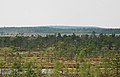
 Rain bog in Lauhanvuori National Park |
||
| location | South Ostrobothnia , Finland | |
| surface | 53 km² | |
| WDPA ID | 7496 | |
| Geographical location | 62 ° 9 ' N , 22 ° 11' E | |
|
||
| Setup date | 1982 | |

The Lauhanvuori National Park (Finnish. Lauhanvuoren kansallispuisto ) is a national park established in 1982 in western Finland .
The 53 km² national park is located in the area of the municipalities of Kauhajoki , Isojoki and Honkajoki in the South Ostrobothnian landscape . It includes forest and marshland in the hilly Suomenselkä moraines.
It is named after the hill Lauhanvuori (231 m), which is also the highest point in the national park. The Finnish relief is characterized by igneous rocks and moraine deposits. The Lauhanvuori represents a geological peculiarity here, as the hill is not a moraine, but a sandstone rock . In contrast to the surrounding moraines, it was not covered by Lake Ancylus , but protruded as an island from the post-glacial meltwater floods. Old coastlines can still be made out today on broad bands on the slopes of the summit, on which the bedrock emerges, and on gravel beds. Sand dunes can also be found on the western slope. Pine trees dominate the partly marshy lowlands, while spruce and birch trees are more common at higher altitudes.
Cranes , capercaillie and red grouse can be found in the park .

Forest on the Lauhanvuori

Wetland in the park
View of the Lauhanvuori


Web links
- Lauhanvuori National Park (English)