Isojoki
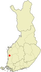
| coat of arms | map |
|---|---|

|

|
| Basic data | |
| State : |
|
| Landscape : | South Ostrobothnia |
| Administrative community : | Suupohja |
| Geographical location | 62 ° 7 ′ N , 21 ° 58 ′ E |
| Surface: | 647.47 km² |
| of which land area: | 642.43 km² |
| of which inland waterways: | 5.04 km² |
| Residents : | 1,976 (Dec. 31, 2018) |
| Population density : | 3.1 inhabitants / km² |
| Municipality number : | 151 |
| Language (s) : | Finnish |
| Website : | isojoki.fi |
Isojoki ( Swedish : Storå ) is a municipality in the South Ostrobothnian countryside in western Finland .
places
The municipality includes the places Heikkilä, Iivarinkylä, Isojoki, Kodesjärvi, Kortteenkylä, Kärjenkoski, Leppikylä, Möykky, Peurala, Polvenkylä, Sakara, Sarviluoma, Suojoki, Vanhakylä, Vesijärvi and Villamo.
coat of arms
Description of the coat of arms : "In the black shield there is a silver post with a red ear of corn ".
Partner municipality
Isojoki maintains a community partnership with the Swedish town of Ljusdal .
Personalities
- Arto Koivisto (* 1948), cross-country skier
Web links
Commons : Isojoki - collection of images, videos and audio files
Individual evidence
- ↑ Maanmittauslaitos (Finnish land surveying office): Suomen pinta-alat kunnittain January 1, 2010 (PDF; 199 kB)
- ↑ Statistical Office Finland: Table 11ra - Key figures on population by region, 1990-2018