Howtwa (village)
| Howtwa | ||
| Говтва | ||

|

|
|
| Basic data | ||
|---|---|---|
| Oblast : | Poltava Oblast | |
| Rajon : | Kozelshchyna district | |
| Height : | 80 m | |
| Area : | Information is missing | |
| Residents : | 417 (2004) | |
| Postcodes : | 39110 | |
| Area code : | +380 5342 | |
| Geographic location : | 49 ° 25 ' N , 33 ° 52' E | |
| KOATUU : | 5322081601 | |
| Administrative structure : | 4 villages | |
| Address: | вул. Леніна 2 39200 с. Говтва |
|
| Statistical information | ||
|
|
||
Howtwa ( Ukrainian Говтва , historically: Ukrainian Голтва Holtwa , Russian Голтва Goltwa ; Russian Говтва Gowtwa , Polish Oltwa ) is a village in Koselschtschyna district of the Central Ukrainian Poltava Oblast with about 400 inhabitants.
Geographical location
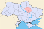
Howtwa lies at the mouth of the Howtwa River in the Psel . In addition to the village of the same name, the district council Howtwa also includes the villages of Bunjakivka ( Буняківка ; 216 inhabitants), Kysseliwka ( Киселівка ; 97 inhabitants) and Plawni ( Плавні ; 14 inhabitants).
history
Howtwa was first mentioned in a document in 1097, when the place was part of the fortification system of the Kievan Rus against steppe peoples invading from the east. In the 12th century it was on the main route between the empire and the Polowzen / Kumanen area in the east . Howtwa was not permanently settled in the Tatar period from the middle of the 13th century. In 1530 there was a battle between Poles and Tatars near the village on the Howtwa River .
From the beginning of the 17th century Howtwa, now part of Poland-Lithuania, was permanently settled again, in 1631 the place became part of the Starost Cherkassy and received fortifications. In 1638 the Cossack hetman Ostranyn was able to successfully repel an attack by warriors from Poland Potozki .
From 1648 the then small town was the seat of a Cossack hundred, which belonged to the Myrhorod group. In 1658 and 1661 there were fighting between Russian fighters and followers of the Hetman Ivan Wyhowskyj at Howtwa , while in 1696 Cossacks fought against Tatars. In August 1692 he was visited by the Cossack hetman Iwan Masepa . After the incorporation of the Cossack state into the Russian Empire, the place was no longer in a border region and thus lost its military importance.
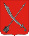
In 1782 Howtwa, then part of the Kyiv Namestnytschestvo, was elevated to the status of a city and the place was given a coat of arms that is very similar to that of the city of Khorol , which is also part of the Kievan Rus fortification system .
In the 19th century, the settlement lost its importance, as the rivers played an increasingly less important role as transport routes and they were not connected to the railway network. Downgraded again to the status of a small town, it came first to the Namestnytschestvo Yekaterynoslaw and then to the Poltava Governorate . At the end of the 19th century, the place had three churches, a school, a weekly and four annual markets. In 1897 Maxim Gorky published a short story, the plot of which takes place at a fair in Howtwa.
In the 20th century the importance of the place decreased further, it only has the status of a village. The churches were destroyed so that today only remnants of the fortifications remind of the former importance of Howtwa. After the place had about 450 inhabitants in 1987, the number of inhabitants has continued to decrease.


