
Hualālai
| Hualālai | ||
|---|---|---|
 Big island of Hawaii, Hualālai at the left edge of the picture |
||
| height | 2521 m | |
| location | Hawaii | |
| Mountains | Hawaiian Islands | |
| Coordinates | 19 ° 41 '32 " N , 155 ° 52' 2" W | |
|
||
| Type | Shield volcano | |
| Age of the rock | <100,000 years | |
| Last eruption | 1801 | |

The Hualālai ( German : Hualalai ) is next to the Kīlauea and the Mauna Loa one of the three active volcanoes in Hawaii , the largest island in the Hawaiian archipelago . It lies west of the saddle between Mauna Kea and Mauna Loa. Its summit is 2521 meters above sea level. The nearest major city is Kailua-Kona , which is on its southern flank.
Eruptions
Between 1700 and 1801 lava emerged in six different places. Lava also got into the ocean. The Keahole Airport , which is located 11 kilometers north of Kailua-Kona, on a large lava field near Keahole Point was built.
Although the Hualālai is not nearly as active as Mauna Loa or Kīlauea , recent research shows that 80 percent of the mountain's surface is covered by lava that is no more than 5000 years old. In the past two decades, when most of the new hotels, private and commercial buildings were being built, there have been relatively few major earthquakes in the region. In 1929 there was a series of earthquakes that lasted over a month. This was probably the result of magma that rose just below the surface. This is one of the reasons why the Hualālai is still viewed as a potentially dangerous volcano today. An outbreak within the next 100 years is very likely.
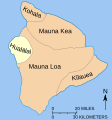
Position of the Hualālai in relation to the other volcanoes

ʻAʻā lava in North Kona with increasing vegetation towards the coast


literature
- Macdonald, GA and AT Abbott. 1970. Volcanoes in the Sea . Univ. of Hawaii Press. 441 pp.
- USGS website: Hualalai, Hawaiʻi's Third Active Volcano
See also
Web links
- Hualālai in the Geographic Names Information System of the United States Geological Survey
- Hualālai in the Global Volcanism Program of the Smithsonian Institution (English)
- Ken Hon, ea: Field interpretation of active volcanoes. A handbook for viewing lava , Geology Dept., University of Hilo, Hawaii, 2008 (PDF, English; 8.3 MB)
- Julia E. Hammer, ea: Submarine sliver in North Kona: A window into the early magmatic and growth history of Hualalai Volcano, Hawaii , Journal of Volcanology and Geothermal Research 151 (2006) 157–188 (PDF, English; 1.8 MB )