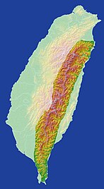
Huatung Valley
The Huatung Valley or Huadong Valley ( Chinese 花 東 縱 谷 , Pinyin Huādōng Zònggǔ ), English sometimes referred to as the East Rift Valley ("Eastern Rift"), is an elongated valley that extends approximately parallel to the east coast of the island of Taiwan .
description
The valley is about 180 kilometers long and 2 to 7 kilometers wide. Its eastern border is formed by the Haian Mountains and the western border is formed by the foothills of the Taiwanese or Chungyang mountain range . The northern half of the valley is in Hualien County and the southern half is in Taitung County . The county's two capitals, Hualien and Taitung , form the approximate northern and southern starting points of the valley. There are three larger rivers in the valley, the Hualien, Xiuguluan and Beinan, all of which flow into the Pacific and are fed by numerous tributaries that arise in the central mountains.
In the area of the valley is the transition or collision zone between the Philippine plate and the Eurasian plate . The eastern Haian Mountains lie on the former, and the central range on the latter. Located on the western edge of the so-called mountain-Haian Chihshang- warp forms the boundary of the Philippine plate cm at a speed of about 2.6 moves toward the northwest per year. Due to its location, the valley is more frequently hit by earthquakes. The most severe quakes in recent times occurred on October 22, 1951 (three earthquakes with a magnitude of about 7) and November 5, 1951 (two earthquakes with a magnitude greater than 6) in the northern section of the valley and claimed more than 80 lives. The epicentres were located in the Huatung Valley retrospectively (at that time Taiwan did not have an accurate measurement system for earthquake activities). Together with the Hualien earthquake in 2018, it was the most serious documented earthquake of modern times on the east coast of Taiwan.
Huatung Valley in recent times
The original inhabitants of the valley were members of the indigenous people of the Amis . From the 19th century, an increasing number of Han Chinese immigrated. The culture of the Ami and other indigenous peoples is still represented in the valley today. B. their expression in folk festivals and customs. During the time of the Japanese rule over Taiwan (1985-1945) the valley was named Nakasendō (中 仙道) or Nakasendō heya (中 仙道 平野, "Nakasendō Plain").
Today's valley is an important artery and is traversed in its entire length by the Taitung Line of the Taiwan Railroad and the provincial Expressway 9, which both connect the cities of Taitung and Hualien. There is a rich and diverse flora and fauna in the valley. Tourism is subsidized by the state and typical tourist activities are e.g. B. cycling or hiking.
Luye municipality at the southern end of the valley
Web links
- East Rift National Scenic Area , official tourist site (English)
Individual evidence
- ↑ Jacques Angelier, Hao-Tsu Chu, Jian-Cheng Lee, Jyr-Ching Hu: Active faulting and earthquake hazard: The case study of the Chihshang Fault, Taiwan . In: Journal of Geodynamics . tape 29 , no. 3-5 , April 2000, pp. 151-185 , doi : 10.1016 / S0264-3707 (99) 00045-9 (English).
- ↑ Chihshang Active Fault Observatory. Institute for Earth Sciences of Academia Sinica, accessed on December 14, 2017 (English).
- ↑ J. Bruce H. Shyu, Ling-Ho Chung, Yue-Gau Chen, Jian-Cheng Lee, Kerry See: Re-evaluation of the surface ruptures of the November 1951 earthquake series in eastern Taiwan, and its neotectonic implications . In: Journal of Asian Earth Sciences . tape 31 , 2007, p. 317–331 , doi : 10.1016 / j.jseaes.2006.07.018 (English).
- ↑ Amis. Taiwan Digital Museum of Indigenous People, archived from the original on November 13, 2017 ; accessed on December 14, 2017 (English).
- ↑ Plants. East Rift National Scenic Area, archived from the original on December 7, 2016 ; accessed on December 14, 2017 (English).


