Hualien County
|
Hualien County 花蓮 縣 |
|||
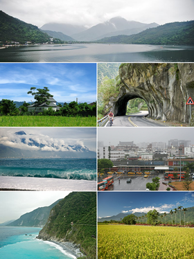
 Left to right and top to bottom: Liyu Lake in Shoufeng, Tobacco Store in Fenglin, Cross Island Highway near Taroko Gorge, Qixingtan Beach in Xincheng, Hualien Train Station, Cingshui Cliffs, rice field in Shoufeng off the Taiwanese foothills Central Mountains |
|||
|
|||
| State : |
|
||
| Coordinates : | 24 ° 0 ′ N , 121 ° 30 ′ E | ||
| Height : | 0 - 3805 m | ||
| Area : | 4,628.6 km² | ||
| Residents : | 328,683 (April 2018) | ||
| Population density : | 71 inhabitants per km² | ||
| Time zone : | UTC + 8 (Chungyuan time) | ||
| Telephone code : | (+886) (0) 3 | ||
| Postal code : | 970-983 | ||
| ISO 3166-2 : | TW-HUA | ||
| District capital : | Hualien ( 花蓮 市 ) | ||
| Structure : | 1 city ( 市 ), 2 municipalities ( 鎮 ) 10 rural municipalities ( 鄉 ) |
||
| District Administrator: | Hsu Chen-wei ( 徐 榛 蔚 ) ( KMT ) | ||
| Website : | |||
| Circle bird: | Blood pyrole ( Oriolus traillii ) | ||
| Circle flower: | Indian lotus flower | ||
| Circle tree: | Poplar fig | ||

|
|||
The district of Hualien ( Chinese 花蓮 縣 , Pinyin Huālián Xiàn , Tongyong Pinyin Hualián Siàn , W.-G. Hua-lien Hsien ) is a district of the Republic of China in Taiwan . It occupies the central part of eastern Taiwan and, with an area of 4628 km², is the largest of all 22 districts and cities in the Republic of China . Its capital is the city of Hualien .
location
Hualien County is bordered by Yilan County to the north, Taichung City to the northwest , Nantou County to the west, Kaohsiung City to the southwest , Taitung County to the south, and the Pacific Ocean to the east .
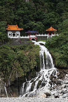
Most of the county is covered by Taiwan's central mountain range , the Chungyang Mountains, which extend to the sea in the northeast. There, the river is located on the lower reaches Liwu the carved into marble rocks Taroko Gorge , one of the greatest natural attractions of Taiwan. The gorge is the most important tourist attraction of the Hualien County and is embedded in the Taroko National Park , which covers almost the entire north of the county.
A narrow coastal plain extends around the district town of Hualien, to the south of which the Huatung Trench separates the central mountains from the up to 1682 m high Haian coastal mountains . The Yushan National Park extends into the southwest of the district. There is the Xiuguluan Shan ( 秀姑 巒 山 ) on the border to the neighboring district of Nantou , the highest mountain in the district of Hualien with 3805 m.
population
Because of its remote location, Chinese settlers did not reach the Hualien County area until the mid-19th century, later than other parts of Taiwan. Today the mountainous district is one of the most sparsely populated regions on the island. The only larger city with about 110,000 inhabitants is the county seat of Hualien.
Hualien County is the main settlement area for the Yanks , the largest indigenous people in Taiwan . It is also home to members of the Atayal , Bunun , Truku , Sakizaya and Kavalan . In total, the indigenous peoples make up around a quarter of the 330,000 inhabitants, and members of the Hakka make up another 30% .
Transport and infrastructure
Hualien County is the only county in Taiwan that is not connected to the motorway network, along with its southern neighbor Taitung . The main roads as well as the main eastern route of the Taiwanese railway traverse the district in a north-south direction. The Tarakoschlucht is the starting point of a 3275 m high pass road over the Hehuanshan into the district of Nantou , which is the only direct road connection through the interior of the island to central and western Taiwan.
The capital, Hualien, has the most important port on Taiwan's east coast and Hualien Airport , which is mainly used for domestic flights . From the airport there are charter flights to other Asian countries, as well as scheduled flights to Hong Kong since December 2016 .
politics
The district's self-governing body is the district council of Hualien ( Chinese 花蓮 縣 議會 , Pinyin Huālián Xiàn Yìhuì ), which consists of 33 delegates and is elected every four years. Traditionally, the Kuomintang has had a strong position in county politics. In the 2014 election she achieved an absolute majority. The head of the district is the district administrator ( 花蓮 縣長 ) , who is elected directly every 4 years .
Symbols of the district
Some plants and animals have been declared official symbols of the district. The poplar fig is the district's official tree. The tree has a certain religious meaning, since the Buddha Siddhartha Gautama is said to have experienced his enlightenment meditating under a fig. The district's bird is the blood pyrole ( Oriolus traillii ), a Taiwanese songbird that got its German name from its deep red belly color, and the district's official flower is the lotus, which also has a certain meaning in Buddhism as a symbol of purity.
cities and communes
| Parishes in Hualien County |
|---|
The county town of Hualien is the only town ( 市 , Shì ) in the county. There are also two urban communities ( 鎮 , Zhèn ) and ten rural communities ( 鄉 , Xiāng ).
Some parishes have Japanese names from the time of Japanese rule over Taiwan between 1895 and 1945. All parishes in the district have the status of " regions of indigenous peoples ", in which indigenous cultures and languages are to receive special promotion. According to the official statistics from April 2018, the population figures and area data for the municipalities were as follows:
| local community | chin. | Hanyu Pinyin | Taiwanese (POJ) | Area (km²) |
Residents | Ew./km² |
|---|---|---|---|---|---|---|
| 1 city | ||||||
| Hualien | 花蓮 市 | Huālián Shì | Hoa-liân-chhī | 29.4095 | 104.003 | 3536 |
| 2 municipalities | ||||||
| Fenglin | 鳳林 鎮 | Fènglín Zhèn | Hōng-lîm-tìn | 120.5181 | 10,857 | 90 |
| Yuli | 玉里 鎮 | Yùlǐ Zhèn | Gio̍k-lí-tìn | 252.3719 | 24,235 | 96 |
| 7 rural communities | ||||||
| Fengbin | 豐 濱 鄉 | Fēngbīn Xiāng | Hong-pin-hiong | 162.4332 | 4515 | 28 |
| Fuli | 富 里 鄉 | Fùlǐ Xiāng | Hù-lí-hiong | 176.3705 | 10,366 | 59 |
| Guangfu | 光復 鄉 | Guāngfù Xiāng | Kong-ho̍k-hiong | 157.1100 | 12,868 | 82 |
| Ji'an | 吉安 鄉 | Jí'ān Xiāng | Kiat-an-hiong | 65.2582 | 83,646 | 1282 |
| Ruisui | 瑞穗 鄉 | Ruìsuì Xiāng | Sūi-sūi-hiong | 135.5862 | 11,694 | 86 |
| Shoufeng | 壽 豐 鄉 | Shòufēng Xiāng | Siū-hong-hiong | 218.4448 | 18,016 | 83 |
| Xincheng | 新 城鄉 | Xīnchéng Xiāng | Sin-siâⁿ-hiong | 29.4095 | 20,104 | 684 |
| 3 mountainous communities of the indigenous people | ||||||
| Wanrong | 萬榮 鄉 | Wànróng Xiāng | Bān-êng-hiong | 618.4910 | 6435 | 10 |
| Xiulin | 秀林 鄉 | Xiùlín Xiāng | Siù-lîm-hiong | 1641.8555 | 15,888 | 10 |
| Zhuoxi | 卓 溪鄉 | Zhuóxī Xiāng | Toh-khe-hiong | 1021.3130 | 6079 | 6th |
Web links
Individual evidence
- ↑ Jim Liu: HK Express adds Hualien service from Dec 2016. routesonline.com, August 15, 2016, accessed December 9, 2017 .
- ↑ 花蓮 縣 議會 (Hualien County Council). District council website, accessed June 9, 2018 (Chinese).
- ↑ 黨團> 中國 國民黨 (party groups> Kuomintang). District council website, accessed June 9, 2018 (Chinese).
- ^ County Tree of Hualien — Religiosa. Hualien County Government website, accessed January 14, 2018 .
- ^ County Bird — Maroon Oriole. Hualien County Government website, accessed January 14, 2018 .
- ^ County Flower. Hualien County Government website, accessed January 14, 2018 .
- ↑ 各 月 人口 資料 (括弧 內 為 資料 起始 年月) 03 鄉鎮 戶數 及 人口 數 (9701) ("Population data for each month (in brackets is the starting month of the data) 03 municipalities and population (9701)"). Taiwan Ministry of the Interior, accessed May 11, 2018 (Chinese).


